IMAGES TAKEN NEAR TO
The Stanners, MORPETH, NE65 0UT
Introduction
This page details the photographs taken nearby to The Stanners, NE65 0UT by members of the Geograph project.
The Geograph project started in 2005 with the aim of publishing, organising and preserving representative images for every square kilometre of Great Britain, Ireland and the Isle of Man.

There are currently over 7.5m images from over14,400 individuals and you can help contribute to the project by visiting https://www.geograph.org.uk
Image Map
Images are licensed for reuse under creativecommons.org/licenses/by-sa/2.0
Notes
- Clicking on the map will re-center to the selected point.
- The higher the marker number, the further away the image location is from the centre of the postcode.
Image Listing (636 Images Found)
Images are licensed for reuse under creativecommons.org/licenses/by-sa/2.0
Image
Details
Distance
1
Masons Arms, Dial Place, Warkworth
Image: © Alexander P Kapp
Taken: 15 Jun 2010
0.01 miles
2
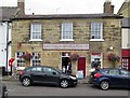
Warkworth Village Store, Dial Place
Warkworth Village Store is the Post Office, Newsagent, General Dealer and Off License. Next to the Masons Arms Image on the west side of Dial Place, 4 Dial Place, formerly an early C19th house, now much altered, is a Grade II Listed Building (List entry Number: 1155178) https://www.historicengland.org.uk/listing/the-list/list-entry/1155178
Image: © Andrew Curtis
Taken: 18 Aug 2018
0.02 miles
3
Warkworth Village Store
The shop and post office at 4 Dial Place is Grade II listed https://historicengland.org.uk/listing/the-list/list-entry/1155178?section=official-list-entry
Image: © Gerald England
Taken: 17 Oct 2022
0.02 miles
4
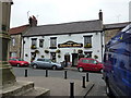
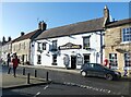
Masons Arms, Dial Place
The Masons Arms in Dial Place, Warkworth is a Grade II Listed building (List entry Number: 1371233): https://www.historicengland.org.uk/listing/the-list/list-entry/1371233
Inside, the ground floor has old transverse beams, one with a painted inscription 'On the 8th of Oct 1715 the EARL OF DERWENTWATER & 40 of his followers Dined in this HOUSE'.
Image: © Andrew Curtis
Taken: 18 Aug 2018
0.02 miles
5
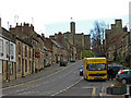
Bottom of Castle Street, Warkworth
Bridge Street goes off to the right. Ahead, Dial Place, leads to St Lawrence Church.
Image: © Andrew Curtis
Taken: 22 Apr 2012
0.03 miles
6
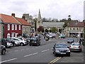
Warkworth
The busy A1068 runs right through Warkworth.
Image: © wfmillar
Taken: 24 Apr 2008
0.03 miles
8
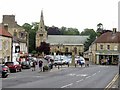
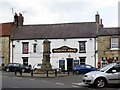
Dial Place, Warkworth
I wondered if the name Dial Place could refer to the sundial above the porch of St Lawrence's Church which faces directly towards the market place Image However, an earlier name was Dial Hill which seems to have referred to the steep hill up to Warkworth Castle, now Castle Street. The Market Cross can be seen in the centre Image On the right side is the former Co-op store, now The Greenhouse. I took a similar view in 2012 Image
Image: © Andrew Curtis
Taken: 18 Aug 2018
0.03 miles
9
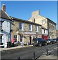
Masons Arms
The Grade II listed https://historicengland.org.uk/listing/the-list/list-entry/1371233?section=official-list-entry Masons Arms dates back to the 17th century though much altered over the years.
Image
Image: © Gerald England
Taken: 17 Oct 2022
0.03 miles
10
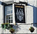
Sign of the Masons Arms
Sign for the Masons Arms Image
Image: © Gerald England
Taken: 17 Oct 2022
0.03 miles