IMAGES TAKEN NEAR TO
Hotspur Court, MORPETH, NE65 0UG
Introduction
This page details the photographs taken nearby to Hotspur Court, NE65 0UG by members of the Geograph project.
The Geograph project started in 2005 with the aim of publishing, organising and preserving representative images for every square kilometre of Great Britain, Ireland and the Isle of Man.

There are currently over 7.5m images from over14,400 individuals and you can help contribute to the project by visiting https://www.geograph.org.uk
Image Map (Loading...)


Getting Data...Please wait
Leaflet Map data © OpenStreetMap
Images are licensed for reuse under creativecommons.org/licenses/by-sa/2.0
Notes
- Clicking on the map will re-center to the selected point.
- The higher the marker number, the further away the image location is from the centre of the postcode.
Image Listing (639 Images Found)
Images are licensed for reuse under creativecommons.org/licenses/by-sa/2.0
Image
Details
Distance
2
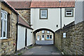
Lane off Castle Street, Warkworth
A lane giving access from Castle Street to the path alongside the River Coquet.
Image: © Jim Barton
Taken: 15 Mar 2022
0.00 miles
3
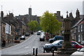
Castle Street, Warkworth
View up Castle Street to the Castle itself.
Image: © Stuart Wilding
Taken: 12 May 2017
0.01 miles
4
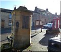
Pant, Castle Street, Warkworth
The pant (public water fountain) outside number 19 Castle Street is Grade II Listed (List entry Number: 1303536): https://www.historicengland.org.uk/listing/the-list/list-entry/1303536
A few metres further up the road, the red, K6-type telephone kiosk is also listed (List entry Number: 1041708) https://www.historicengland.org.uk/listing/the-list/list-entry/1041708
Image: © Gerald England
Taken: 17 Oct 2022
0.01 miles
5
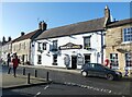
Masons Arms
The Grade II listed https://historicengland.org.uk/listing/the-list/list-entry/1371233?section=official-list-entry Masons Arms dates back to the 17th century though much altered over the years.
Image
Image: © Gerald England
Taken: 17 Oct 2022
0.01 miles
6
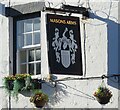
Sign of the Masons Arms
Sign for the Masons Arms Image
Image: © Gerald England
Taken: 17 Oct 2022
0.01 miles
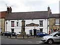
7

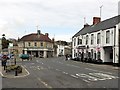
Market Cross, Castle Street, Warkworth
The Market Cross in Castle Street in Warkworth, the Hermitage Inn can be seen in the background.
Image: © Philip Halling
Taken: 2 Jun 2015
0.01 miles
8
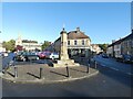
Warkworth Market Cross
The Grade II listed https://historicengland.org.uk/listing/the-list/list-entry/1303500?section=official-list-entry Market Cross probably survives from a 1706 cross whose upper part was replaced c.1830 by the Duke of Northumberland, and restored in C20. It has a square 3-stepped base (bottom step partly under tarmac); cross octagonal above square plinth; restored upper part, above panelled set-back and has sunk cinquefoil-headed panels holding small cast-iron plates with Percy emblems (alternating crescents and fetterlocks). The top has swept panelled dome and cast-iron finial with gilded cross.
The Greenhouse behind it on the A1068 is also Grade II listed https://historicengland.org.uk/listing/the-list/list-entry/1155282?section=official-list-entry and was originally a Co-operative shop and described as "A good example of a small inter-war Co-op building well designed to fit a site of special importance."
On the left at the end of Dial Place is the Grade I listed https://historicengland.org.uk/listing/the-list/list-entry/1303446?section=official-list-entry parish church of St Lawrence.
Image: © Gerald England
Taken: 17 Oct 2022
0.01 miles
9
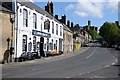
Castle Street, Warkworth
View along Castle Street to Warkworth Castle.
Image: © Philip Halling
Taken: 2 Jun 2015
0.01 miles
10
Masons Arms, Dial Place
The Masons Arms in Dial Place, Warkworth is a Grade II Listed building (List entry Number: 1371233): https://www.historicengland.org.uk/listing/the-list/list-entry/1371233
Inside, the ground floor has old transverse beams, one with a painted inscription 'On the 8th of Oct 1715 the EARL OF DERWENTWATER & 40 of his followers Dined in this HOUSE'.
Image: © Andrew Curtis
Taken: 18 Aug 2018
0.01 miles