IMAGES TAKEN NEAR TO
St. Lawrence Avenue, MORPETH, NE65 0QQ
Introduction
This page details the photographs taken nearby to St. Lawrence Avenue, NE65 0QQ by members of the Geograph project.
The Geograph project started in 2005 with the aim of publishing, organising and preserving representative images for every square kilometre of Great Britain, Ireland and the Isle of Man.

There are currently over 7.5m images from over14,400 individuals and you can help contribute to the project by visiting https://www.geograph.org.uk
Image Map (Loading...)


Getting Data...Please wait
Leaflet Map data © OpenStreetMap
Images are licensed for reuse under creativecommons.org/licenses/by-sa/2.0
Notes
- Clicking on the map will re-center to the selected point.
- The higher the marker number, the further away the image location is from the centre of the postcode.
Image Listing (173 Images Found)
Images are licensed for reuse under creativecommons.org/licenses/by-sa/2.0
Image
Details
Distance
1
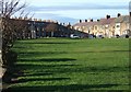
Marine Road and Panhaven Road, Amble
These two terraces close off this green at the western end of Amble Links.
Image: © Derek Harper
Taken: 2 Jan 2007
0.01 miles
2
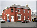
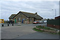
The Harbour Fish Bar in Broomhill Street Amble
Image: © Peter Robinson
Taken: 25 Oct 2012
0.06 miles
4
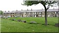
Link End Farm
A green space and the cottages of Panhaven Road.
Image: © Richard Webb
Taken: 16 May 2012
0.09 miles
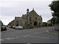
5
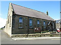
Trinity Methodist Church, Amble
This large stone built chapel, originally called Percy Street Primitive Methodist Chapel, was erected in 1902 and stands on the corner of Leslie Drive and Percy Street.
Image: © Geoff Holland
Taken: 14 Jul 2021
0.10 miles
6

Percy Street, Amble
Solid stonebuilt terrace, typical of the town centre houses.
Image: © Robert Graham
Taken: 4 Jul 2012
0.11 miles
9
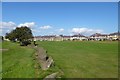
Common land in Amble
Looking across from Links Road to Haven Road and Sea View.
Image: © DS Pugh
Taken: 2 Sep 2014
0.15 miles
10
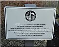
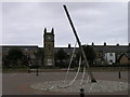
Sign board giving details of coal truck
The staithes are visible across the River Coquet from the harbour.
Image: © Russel Wills
Taken: 26 Jan 2022
0.16 miles