IMAGES TAKEN NEAR TO
Radcliffe, MORPETH, NE65 0HT
Introduction
This page details the photographs taken nearby to NE65 0HT by members of the Geograph project.
The Geograph project started in 2005 with the aim of publishing, organising and preserving representative images for every square kilometre of Great Britain, Ireland and the Isle of Man.

There are currently over 7.5m images from over14,400 individuals and you can help contribute to the project by visiting https://www.geograph.org.uk
Image Map (Loading...)


Getting Data...Please wait
Leaflet Map data © OpenStreetMap
Images are licensed for reuse under creativecommons.org/licenses/by-sa/2.0
Notes
- Clicking on the map will re-center to the selected point.
- The higher the marker number, the further away the image location is from the centre of the postcode.
Image Listing (8 Images Found)
Images are licensed for reuse under creativecommons.org/licenses/by-sa/2.0
Image
Details
Distance
2
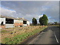
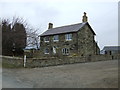
Togston East Farm
Located at the junction of the lane to Togston with the A1068 to Amble.
Image: © Robert Graham
Taken: 4 Jul 2012
0.03 miles
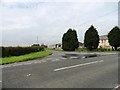
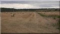
4
Road to Togston and Acklington
Leading westward from the A1068.
Image: © Barbara Carr
Taken: 8 Oct 2013
0.03 miles
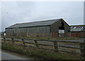
7
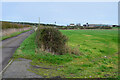
Track to Low Hall
Farmland south of Amble, seen from the verge of the A1068.
Image: © Jim Barton
Taken: 10 Nov 2022
0.18 miles
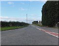
8
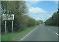
A1068 at Radcliffe village boundary sign
Image: © Colin Pyle
Taken: 30 Apr 2018
0.20 miles