IMAGES TAKEN NEAR TO
Etal Drive, MORPETH, NE65 0GS
Introduction
This page details the photographs taken nearby to Etal Drive, NE65 0GS by members of the Geograph project.
The Geograph project started in 2005 with the aim of publishing, organising and preserving representative images for every square kilometre of Great Britain, Ireland and the Isle of Man.

There are currently over 7.5m images from over14,400 individuals and you can help contribute to the project by visiting https://www.geograph.org.uk
Image Map (Loading...)


Getting Data...Please wait
Leaflet Map data © OpenStreetMap
Images are licensed for reuse under creativecommons.org/licenses/by-sa/2.0
Notes
- Clicking on the map will re-center to the selected point.
- The higher the marker number, the further away the image location is from the centre of the postcode.
Image Listing (6 Images Found)
Images are licensed for reuse under creativecommons.org/licenses/by-sa/2.0
Image
Details
Distance
1
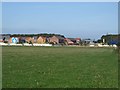
New housing on the edge of Amble
Looking across a grass field towards a new housing development which is being built on the edge of Amble.
Image: © Graham Robson
Taken: 18 Sep 2016
0.08 miles
2

Amble from the air
Coquet Island and lighthouse are also visible.
Image: © Thomas Nugent
Taken: 16 Dec 2018
0.17 miles
3
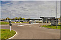
Morrisons Supermarket, Amble
The Morrisons store at Amble is on the Coquet Enterprise Park. The supermarket principally serves people from the locales of Gloster Hill, New Hall, Moor House, Low Hauxley, Amble, Warkworth, Beacon Hill and Broomhill.
Image: © David Dixon
Taken: 22 May 2021
0.18 miles
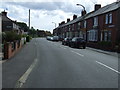
4
Bisley Road, Amble
A residential street in Amble, seen from its junction with Acklington Road.
Image: © Graham Robson
Taken: 11 Sep 2015
0.23 miles
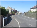
6
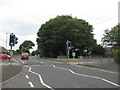
Pedestrian crossing on A1068
Heading out of Amble in Northumberland.
Image: © James Denham
Taken: 3 Aug 2012
0.25 miles