IMAGES TAKEN NEAR TO
Williams Close, MORPETH, NE65 0GF
Introduction
This page details the photographs taken nearby to Williams Close, NE65 0GF by members of the Geograph project.
The Geograph project started in 2005 with the aim of publishing, organising and preserving representative images for every square kilometre of Great Britain, Ireland and the Isle of Man.

There are currently over 7.5m images from over14,400 individuals and you can help contribute to the project by visiting https://www.geograph.org.uk
Image Map (Loading...)


Getting Data...Please wait
Leaflet Map data © OpenStreetMap
Images are licensed for reuse under creativecommons.org/licenses/by-sa/2.0
Notes
- Clicking on the map will re-center to the selected point.
- The higher the marker number, the further away the image location is from the centre of the postcode.
Image Listing (14 Images Found)
Images are licensed for reuse under creativecommons.org/licenses/by-sa/2.0
Image
Details
Distance
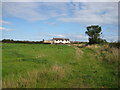
1
Robson's Way, Amble
Housing to the southwest of Amble, photographed on a grey day in September.
Image: © Barbara Carr
Taken: 6 Sep 2013
0.11 miles
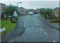
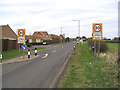
3

Robson's Way, Amble
A residential street on the western edge of Amble.
Image: © Graham Robson
Taken: 11 Sep 2015
0.13 miles
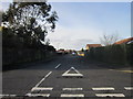
4
Gloster Park, Amble
Looking along Gloster Park, a residential street in Amble, from its junction with Acklington Road.
Image: © Graham Robson
Taken: 11 Sep 2015
0.14 miles
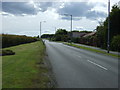
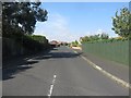
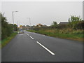
6
Amble
The approach from the southwest on the B6345.
Image: © Walter Baxter
Taken: 14 Mar 2007
0.15 miles
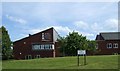
9
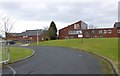
James Calvert Spence College
On the south western outskirts of Amble.
Image: © Russel Wills
Taken: 15 Mar 2013
0.19 miles