IMAGES TAKEN NEAR TO
Sandpiper Way, MORPETH, NE65 0FF
Introduction
This page details the photographs taken nearby to Sandpiper Way, NE65 0FF by members of the Geograph project.
The Geograph project started in 2005 with the aim of publishing, organising and preserving representative images for every square kilometre of Great Britain, Ireland and the Isle of Man.

There are currently over 7.5m images from over14,400 individuals and you can help contribute to the project by visiting https://www.geograph.org.uk
Image Map (Loading...)


Getting Data...Please wait
Leaflet Map data © OpenStreetMap
Images are licensed for reuse under creativecommons.org/licenses/by-sa/2.0
Notes
- Clicking on the map will re-center to the selected point.
- The higher the marker number, the further away the image location is from the centre of the postcode.
Image Listing (8 Images Found)
Images are licensed for reuse under creativecommons.org/licenses/by-sa/2.0
Image
Details
Distance
1
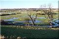
Guilder's Burn flood plain
With snow melt after a thaw of January's snow.
Warkworth Castle can be seen on the horizon. One time stronghold of The Percys. Now in hands of English Heritage.
Image: © David Clark
Taken: 18 Jan 2010
0.03 miles
2
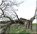
Storm damage
Sycamore tree brought down by gales
Image: © Walter Hall
Taken: 24 Mar 2008
0.15 miles
3
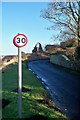
Speed limit over Gloster Hill.
The speed limit sign on Gloster Hill, with dovecote in background.
Image: © David Clark
Taken: 18 Jan 2010
0.16 miles
4
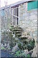
Granary steps
No longer used at the old farm buildings of Gloster Hill farm.
Image: © David Clark
Taken: 18 Jan 2010
0.18 miles

6
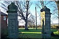
Ruins of The Old Manor House
All that is left of The old Manor House Gloster Hill. The brick property in the left background is Gloster Hill Farmhouse.
Image: © David Clark
Taken: 18 Jan 2010
0.22 miles