IMAGES TAKEN NEAR TO
Sea View, MORPETH, NE65 0BE
Introduction
This page details the photographs taken nearby to Sea View, NE65 0BE by members of the Geograph project.
The Geograph project started in 2005 with the aim of publishing, organising and preserving representative images for every square kilometre of Great Britain, Ireland and the Isle of Man.

There are currently over 7.5m images from over14,400 individuals and you can help contribute to the project by visiting https://www.geograph.org.uk
Image Map (Loading...)


Getting Data...Please wait
Leaflet Map data © OpenStreetMap
Images are licensed for reuse under creativecommons.org/licenses/by-sa/2.0
Notes
- Clicking on the map will re-center to the selected point.
- The higher the marker number, the further away the image location is from the centre of the postcode.
Image Listing (157 Images Found)
Images are licensed for reuse under creativecommons.org/licenses/by-sa/2.0
Image
Details
Distance
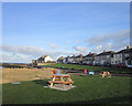
2
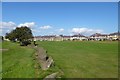
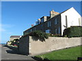
Looking towards Amble from Island View
From Image, looking across the last of Amble Links and the bay east of Pan Point towards Amble Harbour. The prominent house on the headland is Cliff House, and the housing to its left is Gordon Villas.
Image: © Derek Harper
Taken: 2 Jan 2007
0.06 miles
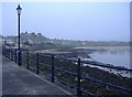
3
Common land in Amble
Looking across from Links Road to Haven Road and Sea View.
Image: © DS Pugh
Taken: 2 Sep 2014
0.06 miles
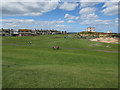
4
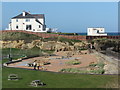
Paddlers Park, Amble
The re-vamped Paddlers Park opened on 20 April 2016 on the site of disused paddling pools. Outdoor adult exercise equipment has been installed, along with a ping pong table and the paddling pools have been replaced with a water feature, and a bright play surface featuring colourful images of puffins, dolphins and hopscotch. The area was also once a sandstone quarry. The large house in the background stands on Pan Point and was built at the time of the construction of the harbour in the 1840's by the Clerk of Works. The building, which overlooked the harbour project, also acted as a 'tommy shop' for the labourers involved in the construction work. The 1901 edition of Brewer's Dictionary of Phrase and Fable notes that the 'tommy shop' is, "where wages are paid to workmen who are expected to lay out a part of the money for the good of the shop. 'Tommy' means bread or a penny roll, or the food taken by a workman in his handkerchief as well as meaning goods in lieu of money.
Image: © Geoff Holland
Taken: 17 Sep 2020
0.06 miles
5
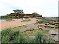
Paddlers Park, Amble
This small but neat area of public open space and adjoining children's play area is known as Paddlers Park as it has been created on the site of a former paddling pool which had become neglected and disused.
Image: © Gordon Hatton
Taken: 15 Aug 2018
0.07 miles
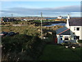
6
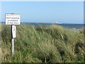
Sign near Paddlers Park, Amble
The sign stands on the edge of a section of dunes and would appear to be intended to prevent golfers practising their bunker shots.
Image: © Geoff Holland
Taken: 17 Sep 2020
0.07 miles
7
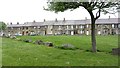
Bay View terraced houses overlooking Amble Harbour
Image: © Peter Robinson
Taken: 7 Oct 2010
0.08 miles
8
Link End Farm
A green space and the cottages of Panhaven Road.
Image: © Richard Webb
Taken: 16 May 2012
0.08 miles