IMAGES TAKEN NEAR TO
Larchwood Avenue, NEWCASTLE UPON TYNE, NE6 4NX
Introduction
This page details the photographs taken nearby to Larchwood Avenue, NE6 4NX by members of the Geograph project.
The Geograph project started in 2005 with the aim of publishing, organising and preserving representative images for every square kilometre of Great Britain, Ireland and the Isle of Man.

There are currently over 7.5m images from over14,400 individuals and you can help contribute to the project by visiting https://www.geograph.org.uk
Image Map
Images are licensed for reuse under creativecommons.org/licenses/by-sa/2.0
Notes
- Clicking on the map will re-center to the selected point.
- The higher the marker number, the further away the image location is from the centre of the postcode.
Image Listing (25 Images Found)
Images are licensed for reuse under creativecommons.org/licenses/by-sa/2.0
Image
Details
Distance
1
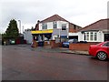
Convenience store, Appletree Gardens, Walkerville, Newcastle upon Tyne
The Booze 'N' Food convenience store at the western end of Appletree Gardens in Walkerville.
Image: © Graham Robson
Taken: 4 Jul 2020
0.08 miles
2
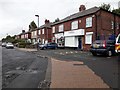
Larchwood Avenue, Walkerville
Semi detached houses on the southern side of Larchwood Avenue in Walkerville. The ground floors of the pair nearest the camera serve as shops. One of them, a hairdresser is open for the first time since mid March due to government imposed rules which forced the closure of non essential businesses as a response to the COVID-19 outbreak which had affected the country.
Image: © Graham Robson
Taken: 4 Jul 2020
0.08 miles
4
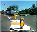
Appletree Gardens
Residential street off Benfield Road. Larchwood Avenue branches off to the right.
Image: © Oliver Dixon
Taken: 14 Mar 2023
0.09 miles
5
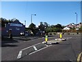
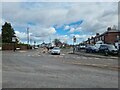
Walkergate Metro Station
Appletree Gardens' junction with Benfield Road.
Image: © Richard Webb
Taken: 1 Oct 2015
0.10 miles
6
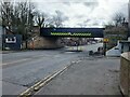
Walkergate Metro Station
The southern limb of the coastal loop of the Tyne and Wear Metro passes over Benfield Road at Walkergate Station.
Image: © Oliver Dixon
Taken: 14 Mar 2023
0.11 miles
7
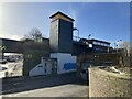
Walkergate Metro Station
Originally opened as Walker on 22 June 1839 by the Newcastle and North Shields Railway, the present station was rebuilt for the Tyne and Wear Metro and reopened on 14 November 1982.
Image: © Anthony Foster
Taken: 18 Feb 2024
0.12 miles
8
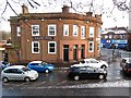
Railway Hotel, Shields Road, Walkergate
Newcastle Libraries have a photo of the pub from 1967 on Flickr: https://www.flickr.com/photos/newcastlelibraries/4078687662/in/photostream
Image: © Andrew Curtis
Taken: 18 Jan 2018
0.12 miles
9
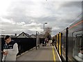
Train at Walkergate Station
Walkergate was one of the former stations of the Newcastle to North Shields Line, originally opened in 1839, which were re-used for the Tyneside Metro in the 1980's. The converted station was re-opened in 1982.
Image: © Robert Graham
Taken: 9 Mar 2020
0.12 miles
10
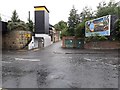
Access to Walkergate Metro Station
A modern lift tower and outdoor staircase provide access to and from the east bound platforms of the Walkergate station on the Tyne and Wear Metro line.
Image: © Graham Robson
Taken: 4 Jul 2020
0.12 miles