IMAGES TAKEN NEAR TO
Dawson Street, NEWCASTLE UPON TYNE, NE6 3NY
Introduction
This page details the photographs taken nearby to Dawson Street, NE6 3NY by members of the Geograph project.
The Geograph project started in 2005 with the aim of publishing, organising and preserving representative images for every square kilometre of Great Britain, Ireland and the Isle of Man.

There are currently over 7.5m images from over14,400 individuals and you can help contribute to the project by visiting https://www.geograph.org.uk
Image Map (Loading...)


Getting Data...Please wait
Leaflet Map data © OpenStreetMap
Images are licensed for reuse under creativecommons.org/licenses/by-sa/2.0
Notes
- Clicking on the map will re-center to the selected point.
- The higher the marker number, the further away the image location is from the centre of the postcode.
Image Listing (3 Images Found)
Images are licensed for reuse under creativecommons.org/licenses/by-sa/2.0
Image
Details
Distance
1
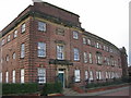
Armstrong Whitworth Shipyard Apprentice School, Walker
Armstrong Whitworth opened the Walker Naval Yard in 1912 and this impressive building is now thankfully restored as office units.
Update: This building was demolished in 2014.
Image: © Alan Fearon
Taken: 5 Nov 2005
0.23 miles
3
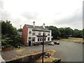
The Crockets Hotel, Walker
On Mitchell Street, which is just west of White Street in Low Walker. Viewed from the Hadrian's Wall Path.
Image: © Robert Graham
Taken: 24 Jul 2013
0.25 miles