IMAGES TAKEN NEAR TO
Anne Walk, NEWCASTLE UPON TYNE, NE6 3HL
Introduction
This page details the photographs taken nearby to Anne Walk, NE6 3HL by members of the Geograph project.
The Geograph project started in 2005 with the aim of publishing, organising and preserving representative images for every square kilometre of Great Britain, Ireland and the Isle of Man.

There are currently over 7.5m images from over14,400 individuals and you can help contribute to the project by visiting https://www.geograph.org.uk
Image Map (Loading...)


Getting Data...Please wait
Leaflet Map data © OpenStreetMap
Images are licensed for reuse under creativecommons.org/licenses/by-sa/2.0
Notes
- Clicking on the map will re-center to the selected point.
- The higher the marker number, the further away the image location is from the centre of the postcode.
Image Listing (7 Images Found)
Images are licensed for reuse under creativecommons.org/licenses/by-sa/2.0
Image
Details
Distance
1
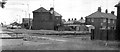
Hibernia Road, Walker
Station Road to the left (running towards Wallsend), Hibernia Road running diagonally right.
Image: © Donald MacDonald
Taken: Unknown
0.09 miles
4
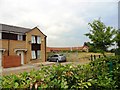
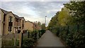
Church Street, Walker
A lot of new housing has been built in this lower end of Walker, near the River Tyne. Viewed from the Hadrian's Wall Path, which runs right beside the houses.
Image: © Robert Graham
Taken: 24 Jul 2013
0.19 miles
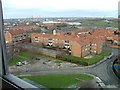
5
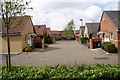
Housing in Walker
New development around Annville Crescent.
Image: © Bill Boaden
Taken: 20 Apr 2017
0.19 miles
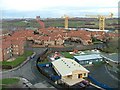
7
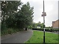
Cycle /foot path
Hadrian's Way / National Cycle Network on the trackbed of the Newcastle and Tynemouth Railway.
This is now quite a busy commuter route.
Image: © Richard Webb
Taken: 31 Jul 2012
0.22 miles