IMAGES TAKEN NEAR TO
Walker Road, NEWCASTLE UPON TYNE, NE6 3EW
Introduction
This page details the photographs taken nearby to Walker Road, NE6 3EW by members of the Geograph project.
The Geograph project started in 2005 with the aim of publishing, organising and preserving representative images for every square kilometre of Great Britain, Ireland and the Isle of Man.

There are currently over 7.5m images from over14,400 individuals and you can help contribute to the project by visiting https://www.geograph.org.uk
Image Map (Loading...)


Getting Data...Please wait
Leaflet Map data © OpenStreetMap
Images are licensed for reuse under creativecommons.org/licenses/by-sa/2.0
Notes
- Clicking on the map will re-center to the selected point.
- The higher the marker number, the further away the image location is from the centre of the postcode.
Image Listing (6 Images Found)
Images are licensed for reuse under creativecommons.org/licenses/by-sa/2.0
Image
Details
Distance
2

Lightfoot Sports Stadium
An innovative design but vandals still manage to graffiti the very top of the dome!
Image: © Christine Westerback
Taken: 14 Aug 2005
0.13 miles
3
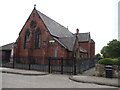
The Church of St Anthony of Egypt, Walker
Image: © Bill Henderson
Taken: 11 Jun 2012
0.13 miles
5
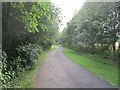
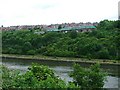
Cycle /foot path, St Anthony's
A busy commuter route on the trackbed of the Newcastle and Tynemouth Railway.
Image: © Richard Webb
Taken: 31 Jul 2012
0.24 miles