IMAGES TAKEN NEAR TO
NE63 9ZF
Introduction
This page details the photographs taken nearby to NE63 9ZF by members of the Geograph project.
The Geograph project started in 2005 with the aim of publishing, organising and preserving representative images for every square kilometre of Great Britain, Ireland and the Isle of Man.

There are currently over 7.5m images from over14,400 individuals and you can help contribute to the project by visiting https://www.geograph.org.uk
Image Map
Images are licensed for reuse under creativecommons.org/licenses/by-sa/2.0
Notes
- Clicking on the map will re-center to the selected point.
- The higher the marker number, the further away the image location is from the centre of the postcode.
Image Listing (21 Images Found)
Images are licensed for reuse under creativecommons.org/licenses/by-sa/2.0
Image
Details
Distance
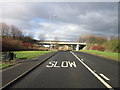
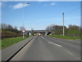
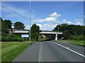
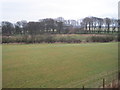
4
Approaching Woodburn
The bridge carries a railway to supply the power station at Lynemouth.
Image: © Russel Wills
Taken: 21 Sep 2014
0.07 miles
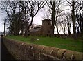
5

The former Church of St Mary the Virgin, Woodhorn.
Now a museum, and used by artists
Image: © John Lord
Taken: 27 Mar 2010
0.08 miles
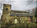
8
Church of St Mary The Virgin, Woodhorn
Image: © Bill Henderson
Taken: 19 Sep 2007
0.08 miles
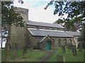
9
Woodhorn Church
Church of St Mary at Woodhorn near Newbiggin. This dates back to the 11th century, although it has been much modified over the years.
Image: © Robert Graham
Taken: 14 Dec 2011
0.09 miles
10

Ordnance Survey Cut Mark
This OS cut mark can be found on St Mary the Virgin's Church.
Image: © Adrian Dust
Taken: 9 Oct 2015
0.09 miles