IMAGES TAKEN NEAR TO
Woodhorn, ASHINGTON, NE63 9YQ
Introduction
This page details the photographs taken nearby to NE63 9YQ by members of the Geograph project.
The Geograph project started in 2005 with the aim of publishing, organising and preserving representative images for every square kilometre of Great Britain, Ireland and the Isle of Man.

There are currently over 7.5m images from over14,400 individuals and you can help contribute to the project by visiting https://www.geograph.org.uk
Image Map
Images are licensed for reuse under creativecommons.org/licenses/by-sa/2.0
Notes
- Clicking on the map will re-center to the selected point.
- The higher the marker number, the further away the image location is from the centre of the postcode.
Image Listing (7 Images Found)
Images are licensed for reuse under creativecommons.org/licenses/by-sa/2.0
Image
Details
Distance
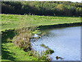
1
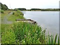
Fishing stages in Queen Elizabeth Country Park
Queen Elizabeth Country Park, incorporating a large lake, was opened by Queen Elizabeth the Queen Mother in 1979 on the restored site of a vast coal-mining area.
Image: © Oliver Dixon
Taken: 13 Jul 2011
0.14 miles
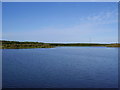
3
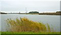
Lake, Queen Elizabeth II Country Park
The QE II Country Park contains this large lake surrounded by planted trees. The distinctive 4-paired chimneys of the Alcan Aluminium Works Image can be seen beyond the lake, on the right.
Image: © Andrew Curtis
Taken: 21 Nov 2009
0.20 miles
4
Queen Elizabeth II Country Park near Woodhorn
Image: © P Glenwright
Taken: 29 Oct 2006
0.20 miles
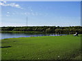
5
Queen Elizabeth II Country Park
Former site of pit heaps
Image: © P Glenwright
Taken: 29 Oct 2006
0.22 miles
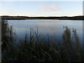
7
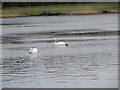
Mute Swans on the lake
At Queen Elizabeth II Country Park, Ashington. This is a big lake on a reclaimed colliery site. There are always plenty of birds on it.
Image: © Robert Graham
Taken: 4 Jan 2012
0.23 miles