IMAGES TAKEN NEAR TO
Woodhorn Village, ASHINGTON, NE63 9YA
Introduction
This page details the photographs taken nearby to NE63 9YA by members of the Geograph project.
The Geograph project started in 2005 with the aim of publishing, organising and preserving representative images for every square kilometre of Great Britain, Ireland and the Isle of Man.

There are currently over 7.5m images from over14,400 individuals and you can help contribute to the project by visiting https://www.geograph.org.uk
Image Map (Loading...)


Getting Data...Please wait
Leaflet Map data © OpenStreetMap
Images are licensed for reuse under creativecommons.org/licenses/by-sa/2.0
Notes
- Clicking on the map will re-center to the selected point.
- The higher the marker number, the further away the image location is from the centre of the postcode.
Image Listing (35 Images Found)
Images are licensed for reuse under creativecommons.org/licenses/by-sa/2.0
Image
Details
Distance
1

Woodhorn Village
Old stone houses at Woodhorn, near Newbiggin.
Image: © Robert Graham
Taken: 14 Dec 2011
0.02 miles
2
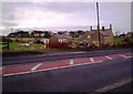
Woodhorn from the west
Viewed from the A197, the road which comes along from Ashington to Newbiggin. Woodhorn church can be seen in the trees to the left.
Image: © Robert Graham
Taken: 14 Dec 2011
0.06 miles
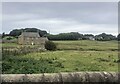
4
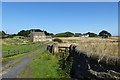
Farm near Woodhorn
Just off the road to Newbiggin.
Image: © DS Pugh
Taken: 2 Sep 2014
0.09 miles
5
View north at Woodhorn
View from the A197, the road into Newbiggin. Woodhorn dates back to medieval times, but is now just a small hamlet.
Image: © Robert Graham
Taken: 14 Dec 2011
0.09 miles
6
Former Woodhorn Mill
A small burn runs in front of this house. In the distance is a chimney at Lynemouth Power Station
Image: © Eirian Evans
Taken: 14 Sep 2021
0.10 miles
7
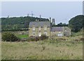
House at Woodhorn
The chimneys of the old aluminium works and the tower of an old windmill tell of former industry and in the distance a wind turbine of a new industry.
Image: © Russel Wills
Taken: 21 Sep 2014
0.10 miles
8

Woodhorn Mill
This is the name on OS large scale maps, which have the same name for the disused windmill. Just 100 metres or so distant, and with no obvious signs of water usage, this suggests that it may have been the house of the miller from the windmill.
Image: © Alan Murray-Rust
Taken: 24 Dec 2009
0.10 miles
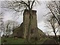
10

Ordnance Survey Cut Mark
This OS cut mark can be found on St Mary the Virgin's Church.
Image: © Adrian Dust
Taken: 9 Oct 2015
0.12 miles