IMAGES TAKEN NEAR TO
Porthcawl, ASHINGTON, NE63 9XF
Introduction
This page details the photographs taken nearby to Porthcawl, NE63 9XF by members of the Geograph project.
The Geograph project started in 2005 with the aim of publishing, organising and preserving representative images for every square kilometre of Great Britain, Ireland and the Isle of Man.

There are currently over 7.5m images from over14,400 individuals and you can help contribute to the project by visiting https://www.geograph.org.uk
Image Map (Loading...)


Getting Data...Please wait
Leaflet Map data © OpenStreetMap
Images are licensed for reuse under creativecommons.org/licenses/by-sa/2.0
Notes
- Clicking on the map will re-center to the selected point.
- The higher the marker number, the further away the image location is from the centre of the postcode.
Image Listing (8 Images Found)
Images are licensed for reuse under creativecommons.org/licenses/by-sa/2.0
Image
Details
Distance
2
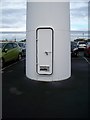
Base of wind Turbine
The maintenance entrance door at the base of the wind turbine at Wansbeck General Hospital
Image: © David Clark
Taken: 25 Oct 2010
0.17 miles
3
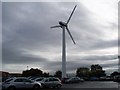
Wind Turbine in Car Park
In the Car Park at Wansbeck Hospital.Providing electricity for the General Hospital.
Image: © David Clark
Taken: 25 Oct 2010
0.20 miles
4
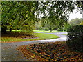
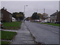
The Flower Park
Leafy park sandwiched in between Ashington's terraces.
Image: © MSX
Taken: 24 Oct 2005
0.22 miles
5
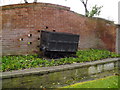
Coal Wagon Sculpture
Ashington's proud industrial heritage is remembered in this corner of the Flower Park.
Image: © MSX
Taken: 24 Oct 2005
0.22 miles
7
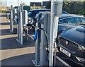
EV charging points
There is an impressive array of EV charging points for visitors to Wansbeck General Hospital.
Image: © Oliver Dixon
Taken: 12 Oct 2023
0.22 miles
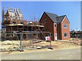
8
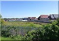
New housing at North Seaton
Viewed from Wansbeck Hospital grounds.
Image: © Russel Wills
Taken: 9 Jun 2015
0.23 miles