IMAGES TAKEN NEAR TO
Debdon Road, ASHINGTON, NE63 9QX
Introduction
This page details the photographs taken nearby to Debdon Road, NE63 9QX by members of the Geograph project.
The Geograph project started in 2005 with the aim of publishing, organising and preserving representative images for every square kilometre of Great Britain, Ireland and the Isle of Man.

There are currently over 7.5m images from over14,400 individuals and you can help contribute to the project by visiting https://www.geograph.org.uk
Image Map
Images are licensed for reuse under creativecommons.org/licenses/by-sa/2.0
Notes
- Clicking on the map will re-center to the selected point.
- The higher the marker number, the further away the image location is from the centre of the postcode.
Image Listing (10 Images Found)
Images are licensed for reuse under creativecommons.org/licenses/by-sa/2.0
Image
Details
Distance
1
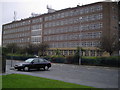
Northumberland College
Huge, impressive looking college in the heart of Ashington.
Image: © MSX
Taken: 24 Oct 2005
0.07 miles
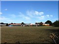
2

Hirst High School
Main block of this well-respected school.
Image: © MSX
Taken: 24 Oct 2005
0.07 miles
3
The Northumberland C of E Academy Richard Grainger Campus
Closed
Image: © Alex McGregor
Taken: 9 Oct 2012
0.08 miles


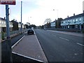
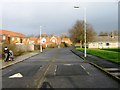
8
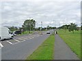
Newbigin Road, North Seaton
Green space along the main B1334 road into North Seaton.
Image: © Oliver Dixon
Taken: 13 Jul 2011
0.22 miles
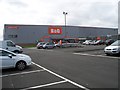
9
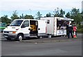
Ultimate Fast Food?
A popular fast food outlet outside B&Q on North Seaton Industrial Estate.
Image: © David Clark
Taken: 26 Aug 2012
0.24 miles