IMAGES TAKEN NEAR TO
Ellington Road, ASHINGTON, NE63 8TU
Introduction
This page details the photographs taken nearby to Ellington Road, NE63 8TU by members of the Geograph project.
The Geograph project started in 2005 with the aim of publishing, organising and preserving representative images for every square kilometre of Great Britain, Ireland and the Isle of Man.

There are currently over 7.5m images from over14,400 individuals and you can help contribute to the project by visiting https://www.geograph.org.uk
Image Map (Loading...)


Getting Data...Please wait
Leaflet Map data © OpenStreetMap
Images are licensed for reuse under creativecommons.org/licenses/by-sa/2.0
Notes
- Clicking on the map will re-center to the selected point.
- The higher the marker number, the further away the image location is from the centre of the postcode.
Image Listing (6 Images Found)
Images are licensed for reuse under creativecommons.org/licenses/by-sa/2.0
Image
Details
Distance
1
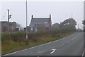
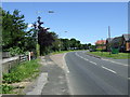
Hawthorn Cottage
On the A1068 north of Ashington.
On a misty, grey day!
Image: © Russel Wills
Taken: 5 Nov 2015
0.14 miles
2
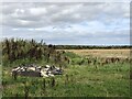
Ungrazed land on the edge of Ashington
A couple of scary notices on the gate warning of the horrible things that the cattle (which have not been here in ages) could do to you. Probably in a housing company's land bank.
Image: © Richard Webb
Taken: 19 Aug 2023
0.22 miles
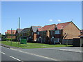
6
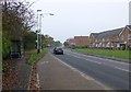
Bus stop and new housing
Beside the A1068 north of Ashington.
Image: © Russel Wills
Taken: 5 Nov 2015
0.25 miles