IMAGES TAKEN NEAR TO
Haldane Street, ASHINGTON, NE63 8SF
Introduction
This page details the photographs taken nearby to Haldane Street, NE63 8SF by members of the Geograph project.
The Geograph project started in 2005 with the aim of publishing, organising and preserving representative images for every square kilometre of Great Britain, Ireland and the Isle of Man.

There are currently over 7.5m images from over14,400 individuals and you can help contribute to the project by visiting https://www.geograph.org.uk
Image Map
Images are licensed for reuse under creativecommons.org/licenses/by-sa/2.0
Notes
- Clicking on the map will re-center to the selected point.
- The higher the marker number, the further away the image location is from the centre of the postcode.
Image Listing (33 Images Found)
Images are licensed for reuse under creativecommons.org/licenses/by-sa/2.0
Image
Details
Distance
1
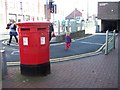
Royal Mail Postbox
Outside the Post office in Ashington.
Image: © David Clark
Taken: 25 Sep 2009
0.06 miles
2
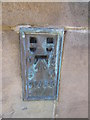
Ordnance Survey Flush Bracket (S1484)
This OS Flush Bracket can be found on the SE angle of the Council Offices. It marks a point 36.971m above mean sea level.
Image: © Adrian Dust
Taken: 9 Oct 2015
0.06 miles
3
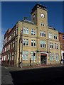
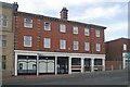
Ashington Town Hall
Ashington Town Hall on Station Road houses offices used by Northumberland County Council and the town council.
Image: © Graham Robson
Taken: 13 Oct 2015
0.07 miles
4
Ashington old fire station
Ashington old fire station, Station Road, Ashington, County Durham.
The building was used by the Mines Rescue Service, who also attended fires in the town, and at collieries across the north east of England
Image: © Kevin Hale
Taken: 2 Aug 2010
0.08 miles
5

Ashington Town hall
Ashington town Hall, no longer open to the public.
Image: © David Clark
Taken: 25 Sep 2009
0.08 miles
6
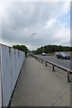
Bridge over the railway
Carrying the A197 above the railway.
Image: © DS Pugh
Taken: 4 Jul 2015
0.08 miles
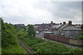
8
Freight line at Ashington
This freight-only line is part of the Blyth and Tyne Railway network, constructed originally to serve the collieries of south-east Northumberland. This branch runs from Ashington northwards past the open cast workings at Linton to join the East Coast Main Line near Widdrington Station.
Image: © Oliver Dixon
Taken: 13 Jul 2011
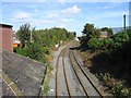
0.09 miles
9
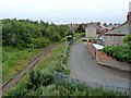
Disused railway
Marked as dismantled on the map, but still appears to exist, if not in a usable state.
Image: © DS Pugh
Taken: 4 Jul 2015
0.09 miles