IMAGES TAKEN NEAR TO
Epsom Drive, ASHINGTON, NE63 8NA
Introduction
This page details the photographs taken nearby to Epsom Drive, NE63 8NA by members of the Geograph project.
The Geograph project started in 2005 with the aim of publishing, organising and preserving representative images for every square kilometre of Great Britain, Ireland and the Isle of Man.

There are currently over 7.5m images from over14,400 individuals and you can help contribute to the project by visiting https://www.geograph.org.uk
Image Map
Images are licensed for reuse under creativecommons.org/licenses/by-sa/2.0
Notes
- Clicking on the map will re-center to the selected point.
- The higher the marker number, the further away the image location is from the centre of the postcode.
Image Listing (3 Images Found)
Images are licensed for reuse under creativecommons.org/licenses/by-sa/2.0
Image
Details
Distance
1
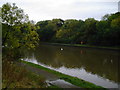
Wansbeck at Stakeford Bridge
More unspoilt riverside.
Image: © MSX
Taken: 24 Oct 2005
0.14 miles
2
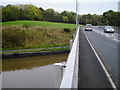
Towards Ashington
Over Stakeford Bridge lies Ashington. Industrial estate just visible behind trees.
Image: © MSX
Taken: 24 Oct 2005
0.14 miles
3
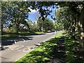
North Station Road, Ashington
Towards the town centre.
Image: © Richard Webb
Taken: 19 Aug 2023
0.22 miles