IMAGES TAKEN NEAR TO
Dene View, ASHINGTON, NE63 8JF
Introduction
This page details the photographs taken nearby to Dene View, NE63 8JF by members of the Geograph project.
The Geograph project started in 2005 with the aim of publishing, organising and preserving representative images for every square kilometre of Great Britain, Ireland and the Isle of Man.

There are currently over 7.5m images from over14,400 individuals and you can help contribute to the project by visiting https://www.geograph.org.uk
Image Map
Images are licensed for reuse under creativecommons.org/licenses/by-sa/2.0
Notes
- Clicking on the map will re-center to the selected point.
- The higher the marker number, the further away the image location is from the centre of the postcode.
Image Listing (5 Images Found)
Images are licensed for reuse under creativecommons.org/licenses/by-sa/2.0
Image
Details
Distance
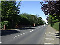
1
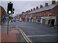
Station Road
Popular shopping street leading out of town centre.
Image: © MSX
Taken: 23 Oct 2005
0.15 miles
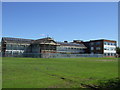
2

Grounds, Ashington High School and Sports College
Image: © JThomas
Taken: 21 Jul 2012
0.18 miles
5
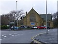
The Holy Sepulchre Church, Ashington
In the former colliery town of Ashington known locally as the Miners’ Church because of its strong links to Northumberland’s once-mighty coal industry.
Image: © Russel Wills
Taken: 17 Jan 2014
0.24 miles