IMAGES TAKEN NEAR TO
Station Road, ASHINGTON, NE63 8HF
Introduction
This page details the photographs taken nearby to Station Road, NE63 8HF by members of the Geograph project.
The Geograph project started in 2005 with the aim of publishing, organising and preserving representative images for every square kilometre of Great Britain, Ireland and the Isle of Man.

There are currently over 7.5m images from over14,400 individuals and you can help contribute to the project by visiting https://www.geograph.org.uk
Image Map
Images are licensed for reuse under creativecommons.org/licenses/by-sa/2.0
Notes
- Clicking on the map will re-center to the selected point.
- The higher the marker number, the further away the image location is from the centre of the postcode.
Image Listing (13 Images Found)
Images are licensed for reuse under creativecommons.org/licenses/by-sa/2.0
Image
Details
Distance
1
The Portland
The Portland has been in Ashington since around 1890 standing in a prominent position on Station Road. With history including the FA Cup showcased by Jackie Milburn in 1951 alongside colourful publican Bill Kell who managed The Portland at the time. A published local paperback tells stories of fantastic times when The Portland was a hive of activity and a real community based venue.
http://www.theportlandashington.com/
Image: © Russel Wills
Taken: 17 Jan 2014
0.03 miles
2
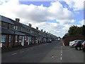
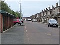
Eighth Row
Rows of what were presumably mining houses.
Image: © DS Pugh
Taken: 4 Jul 2015
0.06 miles
3
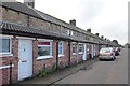
Houses on Ninth Row
Rows of originally identical housing in Ashington.
Image: © DS Pugh
Taken: 4 Jul 2015
0.09 miles
4
Ninth Row, Ashington
National Cycle Network route 155 is routed along this back street.
Image: © Oliver Dixon
Taken: 13 Jul 2011
0.10 miles
5
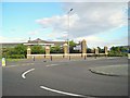
Entrance to Wansbeck Business Park
Quite an imposing entrance statement, and a very attractive business park when you get inside.
Image: © Antony Dixon
Taken: 22 Aug 2012
0.14 miles
6
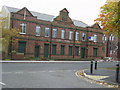
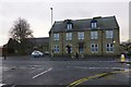
Police Station
The Old Police Station at Ashington
Image: © george hurrell
Taken: 12 Nov 2006
0.14 miles
7
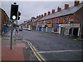
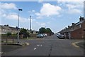
Station Road
Popular shopping street leading out of town centre.
Image: © MSX
Taken: 23 Oct 2005
0.15 miles
8
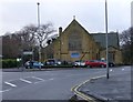
The Holy Sepulchre Church, Ashington
In the former colliery town of Ashington known locally as the Miners’ Church because of its strong links to Northumberland’s once-mighty coal industry.
Image: © Russel Wills
Taken: 17 Jan 2014
0.16 miles
9

Booths Road joins the A197
Rotary Parkway to the right and Morpeth Road to the left.
Image: © Russel Wills
Taken: 17 Jan 2014
0.19 miles