IMAGES TAKEN NEAR TO
Stonecross, ASHINGTON, NE63 8EE
Introduction
This page details the photographs taken nearby to Stonecross, NE63 8EE by members of the Geograph project.
The Geograph project started in 2005 with the aim of publishing, organising and preserving representative images for every square kilometre of Great Britain, Ireland and the Isle of Man.

There are currently over 7.5m images from over14,400 individuals and you can help contribute to the project by visiting https://www.geograph.org.uk
Image Map
Images are licensed for reuse under creativecommons.org/licenses/by-sa/2.0
Notes
- Clicking on the map will re-center to the selected point.
- The higher the marker number, the further away the image location is from the centre of the postcode.
Image Listing (7 Images Found)
Images are licensed for reuse under creativecommons.org/licenses/by-sa/2.0
Image
Details
Distance
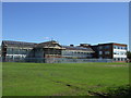
1
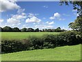
Sports field, Ashington
Off Briardene. Taken from an earth mound above the road.
Image: © Richard Webb
Taken: 19 Aug 2023
0.09 miles
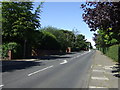
7

Grounds, Ashington High School and Sports College
Image: © JThomas
Taken: 21 Jul 2012
0.23 miles