IMAGES TAKEN NEAR TO
Northumberland Close, ASHINGTON, NE63 8BF
Introduction
This page details the photographs taken nearby to Northumberland Close, NE63 8BF by members of the Geograph project.
The Geograph project started in 2005 with the aim of publishing, organising and preserving representative images for every square kilometre of Great Britain, Ireland and the Isle of Man.

There are currently over 7.5m images from over14,400 individuals and you can help contribute to the project by visiting https://www.geograph.org.uk
Image Map
Images are licensed for reuse under creativecommons.org/licenses/by-sa/2.0
Notes
- Clicking on the map will re-center to the selected point.
- The higher the marker number, the further away the image location is from the centre of the postcode.
Image Listing (16 Images Found)
Images are licensed for reuse under creativecommons.org/licenses/by-sa/2.0
Image
Details
Distance
1
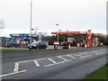
Fuel filling station, Morpeth Road, Ashington
A fuel filling station selling petrol and diesel on Morpeth Road.
Image: © Graham Robson
Taken: 16 Jan 2016
0.06 miles
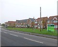
3
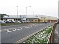
Retail stores, Morpeth Road, Ashington
Three different retail businesses occupy parts of a large building on Morpeth Road. Aldi, Domino's Pizza and Maxwells DIY all share the large building.
Image: © Graham Robson
Taken: 16 Jan 2016
0.17 miles
4

Booths Road joins the A197
Rotary Parkway to the right and Morpeth Road to the left.
Image: © Russel Wills
Taken: 17 Jan 2014
0.21 miles
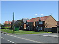
6
New housing beside the A1068
North of Ashington.
Image: © Russel Wills
Taken: 5 Nov 2015
0.21 miles
7
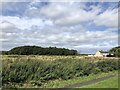
Unused field by Portland Terrace
On the edge of Ashington.
Image: © Richard Webb
Taken: 19 Aug 2023
0.22 miles
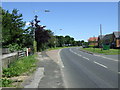
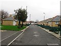
9
Bus stop and new housing
Beside the A1068 north of Ashington.
Image: © Russel Wills
Taken: 5 Nov 2015
0.23 miles
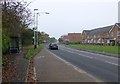
10

Morpeth Road
A small bit of grass between the A197 Morpeth Road and High Market.
Image: © DS Pugh
Taken: 2 Sep 2014
0.23 miles