IMAGES TAKEN NEAR TO
Milburn Road, ASHINGTON, NE63 0PQ
Introduction
This page details the photographs taken nearby to Milburn Road, NE63 0PQ by members of the Geograph project.
The Geograph project started in 2005 with the aim of publishing, organising and preserving representative images for every square kilometre of Great Britain, Ireland and the Isle of Man.

There are currently over 7.5m images from over14,400 individuals and you can help contribute to the project by visiting https://www.geograph.org.uk
Image Map
Images are licensed for reuse under creativecommons.org/licenses/by-sa/2.0
Notes
- Clicking on the map will re-center to the selected point.
- The higher the marker number, the further away the image location is from the centre of the postcode.
Image Listing (3 Images Found)
Images are licensed for reuse under creativecommons.org/licenses/by-sa/2.0
Image
Details
Distance
1

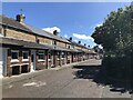
Goalpost in a corner, Hirst
Tightly packed houses leave little play room. Imaginative use of a carpark corner in what would once have been the back gardens of Sycamore Street. Ashington has a proud football history.
Image: © Richard Webb
Taken: 19 Aug 2023
0.07 miles
2
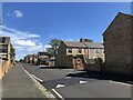
Sycamore Street, Hirst
Row of houses, Ashington
Image: © Richard Webb
Taken: 19 Aug 2023
0.08 miles
3
Fourth Avenue, Hirst
I was taking an undirected route across the grid of miners' rows - possibly the largest such group of houses.
Image: © Richard Webb
Taken: 19 Aug 2023
0.19 miles