IMAGES TAKEN NEAR TO
Heron Close, ASHINGTON, NE63 0DA
Introduction
This page details the photographs taken nearby to Heron Close, NE63 0DA by members of the Geograph project.
The Geograph project started in 2005 with the aim of publishing, organising and preserving representative images for every square kilometre of Great Britain, Ireland and the Isle of Man.

There are currently over 7.5m images from over14,400 individuals and you can help contribute to the project by visiting https://www.geograph.org.uk
Image Map
Images are licensed for reuse under creativecommons.org/licenses/by-sa/2.0
Notes
- Clicking on the map will re-center to the selected point.
- The higher the marker number, the further away the image location is from the centre of the postcode.
Image Listing (20 Images Found)
Images are licensed for reuse under creativecommons.org/licenses/by-sa/2.0
Image
Details
Distance
4
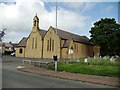
The Church of St John The Evangelist, Ashington
Image: © Bill Henderson
Taken: 9 Jun 2012
0.14 miles
5
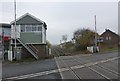
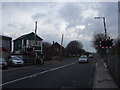
Level crossing in Ashington
The line was opened by the Blyth and Tyne Railway in 1872 but is now used only for freight.
Image: © Russel Wills
Taken: 5 Nov 2015
0.14 miles
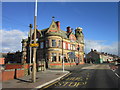
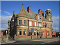
8
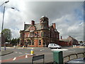
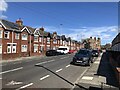
The Elephant Public House, Newbiggin Road, Ashington
Image: © Bill Henderson
Taken: 9 Jun 2012
0.16 miles
9
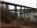
The Black Bridge over the River Wansbeck
Image: © Clive Nicholson
Taken: 8 Mar 2015
0.22 miles
10
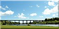
The Black Bridge
Or The North Seaton Viaduct, to give it it's proper Title, crossing The River Wansbeck.
Image: © David Clark
Taken: 28 May 2015
0.22 miles