IMAGES TAKEN NEAR TO
Myrtle Street, ASHINGTON, NE63 0AW
Introduction
This page details the photographs taken nearby to Myrtle Street, NE63 0AW by members of the Geograph project.
The Geograph project started in 2005 with the aim of publishing, organising and preserving representative images for every square kilometre of Great Britain, Ireland and the Isle of Man.

There are currently over 7.5m images from over14,400 individuals and you can help contribute to the project by visiting https://www.geograph.org.uk
Image Map
Images are licensed for reuse under creativecommons.org/licenses/by-sa/2.0
Notes
- Clicking on the map will re-center to the selected point.
- The higher the marker number, the further away the image location is from the centre of the postcode.
Image Listing (29 Images Found)
Images are licensed for reuse under creativecommons.org/licenses/by-sa/2.0
Image
Details
Distance
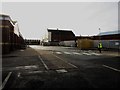
1
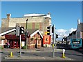
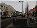
Junction on Woodhorn Road, Ashington
A road junction on Woodhorn Road, Ashington. The road to the left is one of two entrances to the bus station, the other being on Lintonville Terrace. The large building has a large ghost advert painted on its end wall, however large parts of it have been painted over meaning I can't work out who or what it was advertising.
Image: © Graham Robson
Taken: 13 Oct 2015
0.09 miles
2
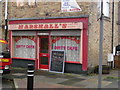
Big Bella's
The most amazing shop front-refers to itself as a "Dirty Cafe"-wonderful.
Image: © MSX
Taken: 24 Oct 2005
0.11 miles
3
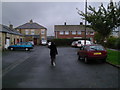
Viewlands
Pit housing and Post-War Semis together on this quiet Cul-de-Sac.
Image: © MSX
Taken: 24 Oct 2005
0.11 miles
4
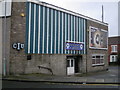
New Hirst & District Social Club
Known locally as "The Mortimer".
Image: © MSX
Taken: 24 Oct 2005
0.11 miles
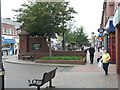
5

Milburn Statue
Situated on Station Road-Ashington's main shopping street-is a statue of footballer Jackie Milburn.
Image: © MSX
Taken: 24 Oct 2005
0.11 miles
6
Station Road, Ashington
The main shopping street in the centre of the town was altered in 2017 to reintroduce traffic in the form of a one way street and parking spaces. The rest of the street was also remodelled with new paving and street furniture.
Image: © Graham Robson
Taken: 24 Jan 2018
0.11 miles
7
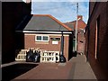
Public toilets, Station Road, Ashington
The small building housing public toilets of Station Road in Ashington.
Image: © Graham Robson
Taken: 13 Oct 2015
0.12 miles
8
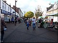
Station Road, Ashington
Looking along the pedestrianised shopping street in Ashington. The wide street is seen on market day with stalls lining the middle of the street.
Image: © Graham Robson
Taken: 13 Oct 2015
0.12 miles
9
Station Road, Ashington
The town has a comprehensive range of shops in the pedestrianised shopping area, Station Road was pedestrianised in 1993.
Image: © Russel Wills
Taken: 16 Jul 2012
0.14 miles
10
Ashington Bus Station
The current location of the temporary bus station in Ashington. In the last year or two the bus station has had several changes to its layout and location whilst the groundworks on the Portland Park site have taken place around it. Currently the stops are located either side of the short piece of road outside the town's Poundstretcher store.
Image: © Graham Robson
Taken: 24 Jan 2018
0.14 miles