IMAGES TAKEN NEAR TO
Roman Avenue, NEWCASTLE UPON TYNE, NE6 2RD
Introduction
This page details the photographs taken nearby to Roman Avenue, NE6 2RD by members of the Geograph project.
The Geograph project started in 2005 with the aim of publishing, organising and preserving representative images for every square kilometre of Great Britain, Ireland and the Isle of Man.

There are currently over 7.5m images from over14,400 individuals and you can help contribute to the project by visiting https://www.geograph.org.uk
Image Map
Images are licensed for reuse under creativecommons.org/licenses/by-sa/2.0
Notes
- Clicking on the map will re-center to the selected point.
- The higher the marker number, the further away the image location is from the centre of the postcode.
Image Listing (15 Images Found)
Images are licensed for reuse under creativecommons.org/licenses/by-sa/2.0
Image
Details
Distance
1
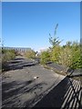
Factory site, Roman Avenue
Hardstanding, colonised by shrubs - a typical post industrial scene.
Image: © Richard Webb
Taken: 1 Oct 2015
0.05 miles
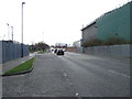
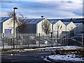
2

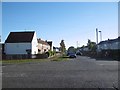
Roman Avenue
View from what was the entrance to a factory.
Image: © Richard Webb
Taken: 1 Oct 2015
0.06 miles
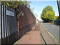
6
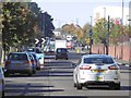
Fossway
A main road following the course of Hadrian's Wall.
Image: © Richard Webb
Taken: 1 Oct 2015
0.15 miles
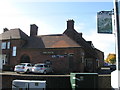
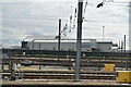
8
Siemens C A Parsons Works, Shields Road
Image: © Andrew Curtis
Taken: 18 Jan 2018
0.17 miles
10
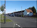
Grace Street
Junction with Roman Avenue.
Image: © Richard Webb
Taken: 1 Oct 2015
0.19 miles