IMAGES TAKEN NEAR TO
Adelphi Place, NEWCASTLE UPON TYNE, NE6 2QD
Introduction
This page details the photographs taken nearby to Adelphi Place, NE6 2QD by members of the Geograph project.
The Geograph project started in 2005 with the aim of publishing, organising and preserving representative images for every square kilometre of Great Britain, Ireland and the Isle of Man.

There are currently over 7.5m images from over14,400 individuals and you can help contribute to the project by visiting https://www.geograph.org.uk
Image Map (Loading...)


Getting Data...Please wait
Leaflet Map data © OpenStreetMap
Images are licensed for reuse under creativecommons.org/licenses/by-sa/2.0
Notes
- Clicking on the map will re-center to the selected point.
- The higher the marker number, the further away the image location is from the centre of the postcode.
Image Listing (11 Images Found)
Images are licensed for reuse under creativecommons.org/licenses/by-sa/2.0
Image
Details
Distance
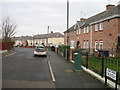
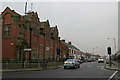
2
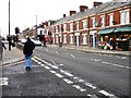
Welbeck Road
Main route through Walker, Newcastle-Upon-Tyne.
Image: © Stephen Sweeney
Taken: 7 Jan 2009
0.08 miles
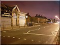
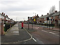
3
Welbeck Road, Walker
Looking west to the roundabout at St Anthony's Road.
Image: © Stephen Sweeney
Taken: 7 Jan 2009
0.09 miles

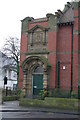
9
Welbeck Road and Walker Library
Looking west towards Newcastle city centre.
Image: © Phil Thirkell
Taken: 16 Jan 2006
0.24 miles