IMAGES TAKEN NEAR TO
Raby Cross, NEWCASTLE UPON TYNE, NE6 2FF
Introduction
This page details the photographs taken nearby to Raby Cross, NE6 2FF by members of the Geograph project.
The Geograph project started in 2005 with the aim of publishing, organising and preserving representative images for every square kilometre of Great Britain, Ireland and the Isle of Man.

There are currently over 7.5m images from over14,400 individuals and you can help contribute to the project by visiting https://www.geograph.org.uk
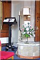
Image Map
Images are licensed for reuse under creativecommons.org/licenses/by-sa/2.0
Notes
- Clicking on the map will re-center to the selected point.
- The higher the marker number, the further away the image location is from the centre of the postcode.
Image Listing (40 Images Found)
Images are licensed for reuse under creativecommons.org/licenses/by-sa/2.0
Image
Details
Distance
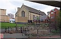
1
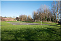
Play area and gardens in Byker
Byker is a district of Newcastle upon Tyne east from the city centre. The area is possibly known as Whickham Gardens but the name might be applicable only to an adjacent residential road.
Image: © Trevor Littlewood
Taken: 8 Mar 2017
0.09 miles
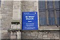
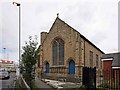
2
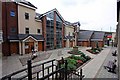
Flats adjacent to St Silas Church, Byker
Image: © John Salmon
Taken: 8 Aug 2008
0.14 miles
3
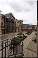
Flats adjacent to St Silas Church, Byker
Image: © John Salmon
Taken: 8 Aug 2008
0.14 miles
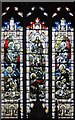
6

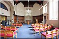
St Silas Church, Byker - West end
West end of church is now a community area.
Image: © John Salmon
Taken: 8 Aug 2008
0.15 miles