IMAGES TAKEN NEAR TO
Shipley Rise, NEWCASTLE UPON TYNE, NE6 2DF
Introduction
This page details the photographs taken nearby to Shipley Rise, NE6 2DF by members of the Geograph project.
The Geograph project started in 2005 with the aim of publishing, organising and preserving representative images for every square kilometre of Great Britain, Ireland and the Isle of Man.

There are currently over 7.5m images from over14,400 individuals and you can help contribute to the project by visiting https://www.geograph.org.uk
Image Map
Images are licensed for reuse under creativecommons.org/licenses/by-sa/2.0
Notes
- Clicking on the map will re-center to the selected point.
- The higher the marker number, the further away the image location is from the centre of the postcode.
Image Listing (137 Images Found)
Images are licensed for reuse under creativecommons.org/licenses/by-sa/2.0
Image
Details
Distance
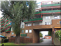
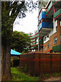
1

Cheviot Mount
Short, low-rise terrace blocks on steep ground with views of the City.
Image: © Andrew Curtis
Taken: 28 Mar 2010
0.03 miles
2
Byker Wall
A section of the 'wall' where it crosses Raby Way.
Image: © Stephen McKay
Taken: 9 Aug 2019
0.03 miles
3

The A193 north of Byker Wall
Bypass for Shields Road built in the late 1980s.
Image: © Andrew Curtis
Taken: 28 Mar 2010
0.04 miles
4
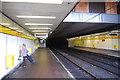
Byker metro station, Newcastle upon Tyne
Looking east towards the tunnel that emerges at Chillingham Rd Station
Image: © hayley green
Taken: 31 Aug 2009
0.04 miles
5
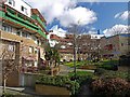
Gardens behind the Byker Wall
Shipley Rise (on the left) looking towards Long Headlam Image
Image: © Andrew Curtis
Taken: 28 Mar 2010
0.04 miles
6

Bridge over the A193 road in Byker
The A193 road links central Newcastle with North Shields. This section of the road by-passes Shields Road in Byker. This picture was taken looking in a westerly direction towards Monument in Central Newcastle. Byker Metro station can just be seen on the right-hand side of the bridge.
Image: © Philip Barker
Taken: 26 Dec 2009
0.04 miles
7
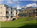
Cheviot Mount, Byker Wall
Small, low-rise terraced blocks protected to the north by the Byker Wall.
Image: © Andrew Curtis
Taken: 28 Mar 2010
0.05 miles
8

The Byker Wall
Part of a futuristic and controversial housing scheme of the 1970s.
Image: © Dr Neil Clifton
Taken: 27 Oct 1979
0.05 miles
9
Byker Wall
The Shipley Rise section of this most iconic of housing developments, seen from Raby Way.
Image: © Stephen McKay
Taken: 9 Aug 2019
0.05 miles
10

The A193 road in Byker (view east)
The A193 road links central Newcastle with North Shields. This section of the road by-passes Shields Road in Byker. This picture was taken from the bridge near East End Swimming Pool looking in an easterly direction towards Wallsend.
Image: © Philip Barker
Taken: 26 Dec 2009
0.05 miles