IMAGES TAKEN NEAR TO
Jane Street, NEWCASTLE UPON TYNE, NE6 2AU
Introduction
This page details the photographs taken nearby to Jane Street, NE6 2AU by members of the Geograph project.
The Geograph project started in 2005 with the aim of publishing, organising and preserving representative images for every square kilometre of Great Britain, Ireland and the Isle of Man.

There are currently over 7.5m images from over14,400 individuals and you can help contribute to the project by visiting https://www.geograph.org.uk
Image Map
Images are licensed for reuse under creativecommons.org/licenses/by-sa/2.0
Notes
- Clicking on the map will re-center to the selected point.
- The higher the marker number, the further away the image location is from the centre of the postcode.
Image Listing (115 Images Found)
Images are licensed for reuse under creativecommons.org/licenses/by-sa/2.0
Image
Details
Distance
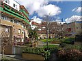
2
Cheviot Mount, Byker Wall
Small, low-rise terraced blocks protected to the north by the Byker Wall.
Image: © Andrew Curtis
Taken: 28 Mar 2010
0.02 miles
4
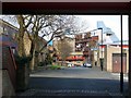
Grace Street towards the Byker Wall
Seen through the frame of the passageway from Spires Lane.
Image: © Andrew Curtis
Taken: 28 Mar 2010
0.03 miles
5

Cheviot Mount
Short, low-rise terrace blocks on steep ground with views of the City.
Image: © Andrew Curtis
Taken: 28 Mar 2010
0.04 miles
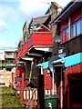
6
Gardens behind the Byker Wall
Shipley Rise (on the left) looking towards Long Headlam Image
Image: © Andrew Curtis
Taken: 28 Mar 2010
0.04 miles
7
Long Headlam, south side of Byker Wall
In the north-east, Grace Lee sector Image
Image: © Andrew Curtis
Taken: 28 Mar 2010
0.05 miles
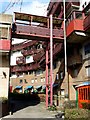
8
Long Headlam, Byker Wall
South side of an eight-storey section of the Byker Wall between Carville and Grace Lee sectors.
Image: © Andrew Curtis
Taken: 28 Mar 2010
0.06 miles
9
View from St Michael's Mount, Byker Estate
In the foreground are the dark roofs of the short blocks of Cheviot Mount, the steepest part of the Byker Estate. Black bird-boxes are attached to each gable. Below are the blue roofs of Kendal, shielded behind its high stretch of the Byker Wall. Tom Collins House, part of the Wall in the Dunn Terrace sector, is on the left.
Image: © Andrew Curtis
Taken: 28 Mar 2010
0.06 miles
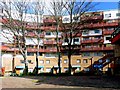
10
The Byker Wall
Wall of houses in the Byker area of Newcastle. Seen from Conyers Road.
Image: © Stephen Sweeney
Taken: 7 Jan 2009
0.06 miles