IMAGES TAKEN NEAR TO
Harbottle Court, NEWCASTLE UPON TYNE, NE6 2AH
Introduction
This page details the photographs taken nearby to Harbottle Court, NE6 2AH by members of the Geograph project.
The Geograph project started in 2005 with the aim of publishing, organising and preserving representative images for every square kilometre of Great Britain, Ireland and the Isle of Man.

There are currently over 7.5m images from over14,400 individuals and you can help contribute to the project by visiting https://www.geograph.org.uk
Image Map (Loading...)


Getting Data...Please wait
Leaflet Map data © OpenStreetMap
Images are licensed for reuse under creativecommons.org/licenses/by-sa/2.0
Notes
- Clicking on the map will re-center to the selected point.
- The higher the marker number, the further away the image location is from the centre of the postcode.
Image Listing (27 Images Found)
Images are licensed for reuse under creativecommons.org/licenses/by-sa/2.0
Image
Details
Distance

3

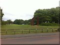
Bank with crocuses and trees
The bank is on the north side of the A186 passing on the south side of Byker, a district of Newcastle upon Tyne east of the city centre.
Image: © Trevor Littlewood
Taken: 8 Mar 2017
0.15 miles
5
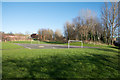
Play area and gardens in Byker
Byker is a district of Newcastle upon Tyne east from the city centre. The area is possibly known as Whickham Gardens but the name might be applicable only to an adjacent residential road.
Image: © Trevor Littlewood
Taken: 8 Mar 2017
0.17 miles
8
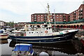
'Speideren', St Peter's Basin Marina
The motor yacht, Speideren (RS 70), was built as a Norwegian Rescue Ship in 1966 and stationed at Sørvær (Finnmark). She is shown here in her original livery:
https://www.redningsselskapet.no/om-oss/redningsskoytene/rs-70-speideren/ https://web.archive.org/web/20210605151449/https://www.redningsselskapet.no/om-oss/redningsskoytene/rs-70-speideren/
There is a painting of her in this role in the Norsk Maritimt Museum https://digitaltmuseum.no/011044253532/r-s-70-speideren-oljemaleri https://web.archive.org/web/20210605150633/https://digitaltmuseum.no/011044253532/r-s-70-speideren-oljemaleri
She was in Stockholm in private ownership in 2003 registered as a dive boat for 12 passengers. After service in Malta she returned to European waters and is under new British ownership. 'Speideren' is Norwegian for 'Scout'.
There is another photo here Image
Image: © Andrew Curtis
Taken: 3 Jun 2021
0.21 miles
9
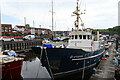
'Speideren', St Peter's Basin Marina
See description here Image
Image: © Andrew Curtis
Taken: 3 Jun 2021
0.21 miles
10
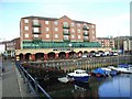
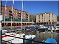
St Peter's Basin
A trendy new boating marina on the north bank of the Tyee. The large building beyond is the Bascule Bar and Bistro.
Seen on a largely traffic-free route which is followed by both Hadrian's Wall National Trail http://www.nationaltrail.co.uk/hadrianswall/ and by route 72 of the National Cycle Network (Hadrian's Cycleway
http://www.cycle-routes.org/HADRIANSCYCLEWAY/ and the Tynemouth branch of the C2C Cycle Route http://www.c2c-guide.co.uk/).
Image: © Oliver Dixon
Taken: 18 Nov 2008
0.21 miles