IMAGES TAKEN NEAR TO
Dereham Terrace, CHOPPINGTON, NE62 5UR
Introduction
This page details the photographs taken nearby to Dereham Terrace, NE62 5UR by members of the Geograph project.
The Geograph project started in 2005 with the aim of publishing, organising and preserving representative images for every square kilometre of Great Britain, Ireland and the Isle of Man.

There are currently over 7.5m images from over14,400 individuals and you can help contribute to the project by visiting https://www.geograph.org.uk
Image Map (Loading...)


Getting Data...Please wait
Leaflet Map data © OpenStreetMap
Images are licensed for reuse under creativecommons.org/licenses/by-sa/2.0
Notes
- Clicking on the map will re-center to the selected point.
- The higher the marker number, the further away the image location is from the centre of the postcode.
Image Listing (16 Images Found)
Images are licensed for reuse under creativecommons.org/licenses/by-sa/2.0
Image
Details
Distance
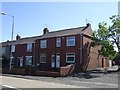
1
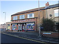
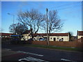
A Newsagents on Dereham Terrace, West Sleekburn
Image: © Ian S
Taken: 2 Feb 2013
0.03 miles
2
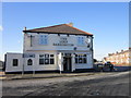
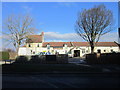
The Lord Barrington public house, West Sleekburn
Image: © Ian S
Taken: 2 Feb 2013
0.05 miles
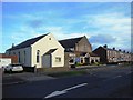
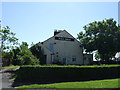
5
The Half Moon public house
On Half Moon Street, Stakeford.
Image: © Ian S
Taken: 2 Feb 2013
0.17 miles
9
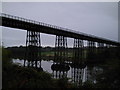
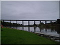
The Black Bridge
Known locally as The Black Bridge, this impressive Victorian span was built to take colliery wagons to and from Woodhorn Pit.
Image: © MSX
Taken: 24 Oct 2005
0.21 miles