IMAGES TAKEN NEAR TO
Ford Street, NEWCASTLE UPON TYNE, NE6 1NW
Introduction
This page details the photographs taken nearby to Ford Street, NE6 1NW by members of the Geograph project.
The Geograph project started in 2005 with the aim of publishing, organising and preserving representative images for every square kilometre of Great Britain, Ireland and the Isle of Man.

There are currently over 7.5m images from over14,400 individuals and you can help contribute to the project by visiting https://www.geograph.org.uk
Image Map (Loading...)


Getting Data...Please wait
Leaflet Map data © OpenStreetMap
Images are licensed for reuse under creativecommons.org/licenses/by-sa/2.0
Notes
- Clicking on the map will re-center to the selected point.
- The higher the marker number, the further away the image location is from the centre of the postcode.
Image Listing (346 Images Found)
Images are licensed for reuse under creativecommons.org/licenses/by-sa/2.0
Image
Details
Distance
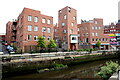
1
'Ince Building' at corner of Ford & Hume Streets, Ouseburn
R & J Ince were formerly builders and timber merchants. The building is now part of Brinkburn Street Bar & kitchen.
Image: © Andrew Curtis
Taken: 3 Jun 2021
0.01 miles
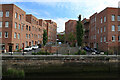
2

Brinkburn Street Bar, Ford Street, Ouseburn
Image: © Andrew Curtis
Taken: 3 Jun 2021
0.01 miles
3
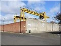
Shepherd's Scrap Metal Works, Ford Street
View here from the gates on Albion Row Image
This business is located on one of the former sites of the world famous Maling Pottery http://en.wikipedia.org/wiki/Maling_pottery
The Maling family had relocated to Newcastle from North Hylton on Wearside in 1815, originally to manufacture plain earthenware jam jars. They built a much larger pottery here in 1858, known as Maling Ford A, and in 1878 an even larger pottery, Ford B, just east of the Ouseburn, now known as Hoult’s Yard Image These factories were the largest and most modern in the world, achieving automated high volume production, a huge range of goods and a good working environment for their staff.
http://www.twsitelines.info/siteline.nsf/SMR/25208F416CC2CB7C802576AF003E6E20
Image: © Andrew Curtis
Taken: 28 Mar 2010
0.02 miles
4
Brinkburn Street Bar & Kitchen, Ford Street, Ouseburn
Image: © Andrew Curtis
Taken: 3 Jun 2021
0.02 miles
5
Kingfisher Place & The Malings, Ouseburn
Image: © Andrew Curtis
Taken: 3 Jun 2021
0.04 miles
7

Information board, Ballast Hills Burial Ground
Image: © Andrew Curtis
Taken: 3 Jun 2021
0.04 miles
8

Ouse Burn
Looking down Ouse Burn from the bridge at the bottom of Byker Bank.
Image: © Peter McDermott
Taken: 23 Aug 2008
0.05 miles
9

View from Walker Road, Newcastle
A scratchy little corner which must have local property developers salivating. The waterway is Ouse Burn, alongside which is Maling Street.
The tall building, distant left, is probably Shieldfield House.
Much more info on the general area here: Image
Image: © Stephen Richards
Taken: 14 Aug 2012
0.05 miles