IMAGES TAKEN NEAR TO
Potts Street, NEWCASTLE UPON TYNE, NE6 1ED
Introduction
This page details the photographs taken nearby to Potts Street, NE6 1ED by members of the Geograph project.
The Geograph project started in 2005 with the aim of publishing, organising and preserving representative images for every square kilometre of Great Britain, Ireland and the Isle of Man.

There are currently over 7.5m images from over14,400 individuals and you can help contribute to the project by visiting https://www.geograph.org.uk
Image Map (Loading...)


Getting Data...Please wait
Leaflet Map data © OpenStreetMap
Images are licensed for reuse under creativecommons.org/licenses/by-sa/2.0
Notes
- Clicking on the map will re-center to the selected point.
- The higher the marker number, the further away the image location is from the centre of the postcode.
Image Listing (90 Images Found)
Images are licensed for reuse under creativecommons.org/licenses/by-sa/2.0
Image
Details
Distance
1
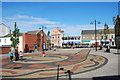
Hadrian Square, Shields Rd, Byker
Taken from the steps of the East End pool and library, the square is a new'ish public square on Shields Road. The square was designed by Artscope and they commissioned Charles Allen at New Castle Delft to produce the ceramic tiles and plaques. archaeologists have confirmed that Hadrians Wall would have run through the Square, at this point we are about 1 1/2 miles west from the end of the Wall, at Wallsend.
Image: © hayley green
Taken: 12 Sep 2009
0.04 miles
2
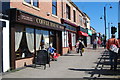
The Coffee House, Shields Rd, Byker (6/13)
A series of photographs of cafes and places to eat in on or just off Shields Rd, Byker.
This is the Coffee House
Image: © hayley green
Taken: 12 Sep 2009
0.04 miles
3
Blue star = beer, red star = bikes
The Edinburgh Bicycle Cooperative on the junction of Union Road and Shields Road. A long way from Bruntsfield.
Image: © Richard Webb
Taken: 1 Oct 2015
0.04 miles
4
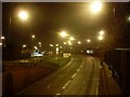
Byker Bridge, Newcastle
Byker Bridge is a road, not a bridge. Looking east from a footbridge over the road.
Image: © Stephen Sweeney
Taken: 7 Jan 2009
0.05 miles
5
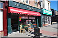
Sawyers Deli, Shields Rd, Byker (7/13)
A series of photographs of cafes and places to eat in on or just off Shields Rd, Byker.
Sawyers Deli
Image: © hayley green
Taken: 12 Sep 2009
0.05 miles
6

East End pool and Library, Shields Road, Byker (1/13)
A series of photos of places to eat in either on, or just off, Shields Road, Byker. This is the new library and has opened in 2000. Inside there is a small cafe serving mainly hot drinks and things with chips.
Image: © hayley green
Taken: 12 Sep 2009
0.06 miles
7
Swimming pool and library, Byker
This picture shows a view of the East End Pool and Library in Byker. The photograph was taken from near Byker Metro station looking in a north-easterly direction towards the roundabout on the B1313 road.
Image: © Philip Barker
Taken: 26 Dec 2009
0.06 miles
8
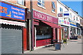
The Singin' Hinny, Shields Rd, Byker (5/13)
A series of photographs of cafes and places to eat on or just off Shields Rd, Byker.
This is the Singin' Hinny.
A singing hinnie is a drop scone and is apparently so called because when it was cooked on a hot griddle it sizzled and was thought to be singing. The tale, as told on a Geordie Recipe site is that 'a north country housewife was baking this scone for tea and on repeatedly being asked by her children if it was ready to eat, her final reply was "No, it's just singing, hinnies". (Hinnies a Geordie term of endearment for children and loved ones)'
Image: © hayley green
Taken: 12 Sep 2009
0.06 miles
9
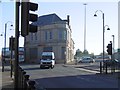
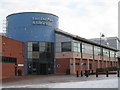
Fossway fire station
Fossway fire station, Union Road, Newcastle-Upon-Tyne, Tyne & Wear, a daytime view of Image
Image: © Kevin Hale
Taken: 4 Jun 2009
0.07 miles
10
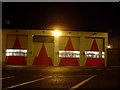
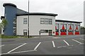
Byker Fire Station
On Union Road in Byker.
Image: © Stephen Sweeney
Taken: 7 Jan 2009
0.07 miles