IMAGES TAKEN NEAR TO
Howburn Crescent, MORPETH, NE61 6RX
Introduction
This page details the photographs taken nearby to Howburn Crescent, NE61 6RX by members of the Geograph project.
The Geograph project started in 2005 with the aim of publishing, organising and preserving representative images for every square kilometre of Great Britain, Ireland and the Isle of Man.

There are currently over 7.5m images from over14,400 individuals and you can help contribute to the project by visiting https://www.geograph.org.uk
Image Map
Images are licensed for reuse under creativecommons.org/licenses/by-sa/2.0
Notes
- Clicking on the map will re-center to the selected point.
- The higher the marker number, the further away the image location is from the centre of the postcode.
Image Listing (10 Images Found)
Images are licensed for reuse under creativecommons.org/licenses/by-sa/2.0
Image
Details
Distance
1
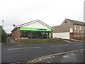
Co-operative Food Supermarket, Pegswood
A typically small Co-operative Food store in the village of Pegswood.
Image: © Graham Robson
Taken: 16 Jan 2016
0.15 miles
2
Pegswood Social Club
A social club in the centre of Pegswood.
Image: © Graham Robson
Taken: 16 Jan 2016
0.16 miles
3

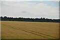
East Coast Main Line
Looking south-west from Pegswood Station. The signals on both side of the line indicate that the railway is signalled for bidirectional operation.
Image: © Alan Murray-Rust
Taken: 12 Jun 2013
0.17 miles
4
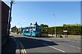
Dark Lane
A bus stand at a stop in Pegswood.
Image: © DS Pugh
Taken: 2 Sep 2014
0.18 miles
5
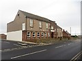
Colliery Housing
Back to back terraced housing, typical of small communities within Northumberland.
Image: © Christine Westerback
Taken: 5 Mar 2006
0.20 miles
8
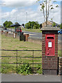
Edward Street/Morpeth postbox ref NE61 217
The official names of postboxes in Pegswood all address them as being in Morpeth, although it is a completely separate village. This is an E II R wall box set in a brick pillar.
Image: © Alan Murray-Rust
Taken: 12 Jun 2013
0.24 miles
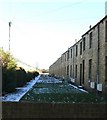
9
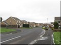
Castleway, Pegswood
Looking along Castleway, a residential street in Pegswood.
Image: © Graham Robson
Taken: 16 Jan 2016
0.24 miles
10
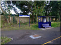
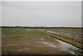
Waiting shelter at Pegswood Station
Pegswood is on the Suburban route from Newcastle to Chathill. Like Chathill, it is served by just two return trains a day. Viewed here from the evening train from Chathill to Newcastle.
Image: © John Lucas
Taken: 16 Aug 2016
0.24 miles