IMAGES TAKEN NEAR TO
West View, MORPETH, NE61 6RP
Introduction
This page details the photographs taken nearby to West View, NE61 6RP by members of the Geograph project.
The Geograph project started in 2005 with the aim of publishing, organising and preserving representative images for every square kilometre of Great Britain, Ireland and the Isle of Man.

There are currently over 7.5m images from over14,400 individuals and you can help contribute to the project by visiting https://www.geograph.org.uk
Image Map (Loading...)


Getting Data...Please wait
Leaflet Map data © OpenStreetMap
Images are licensed for reuse under creativecommons.org/licenses/by-sa/2.0
Notes
- Clicking on the map will re-center to the selected point.
- The higher the marker number, the further away the image location is from the centre of the postcode.
Image Listing (7 Images Found)
Images are licensed for reuse under creativecommons.org/licenses/by-sa/2.0
Image
Details
Distance
1
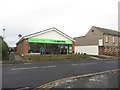
Co-operative Food Supermarket, Pegswood
A typically small Co-operative Food store in the village of Pegswood.
Image: © Graham Robson
Taken: 16 Jan 2016
0.05 miles
2
Pegswood Social Club
A social club in the centre of Pegswood.
Image: © Graham Robson
Taken: 16 Jan 2016
0.10 miles
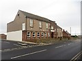
3
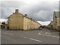
Colliery Housing
Back to back terraced housing, typical of small communities within Northumberland.
Image: © Christine Westerback
Taken: 5 Mar 2006
0.12 miles
4
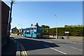
Dark Lane
A bus stand at a stop in Pegswood.
Image: © DS Pugh
Taken: 2 Sep 2014
0.15 miles
5
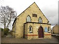
St Margaret's Chapel, Pegswood
The former Primitive Methodist Church in Pegswood village. It is used by the local Methodist Church and the Church of England.
Image: © Graham Robson
Taken: 6 Mar 2017
0.22 miles
6
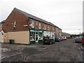
Terrace of shops, Pegswood
A row of traditionally fronted shops in the centre of Pegswood.
Image: © Graham Robson
Taken: 16 Jan 2016
0.24 miles
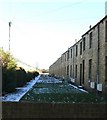
7
Langwell Terrace, Pegswood
A long terrace of brick houses in Pegswood.
Image: © Graham Robson
Taken: 6 Mar 2017
0.25 miles