IMAGES TAKEN NEAR TO
Shadfen, MORPETH, NE61 6NS
Introduction
This page details the photographs taken nearby to NE61 6NS by members of the Geograph project.
The Geograph project started in 2005 with the aim of publishing, organising and preserving representative images for every square kilometre of Great Britain, Ireland and the Isle of Man.

There are currently over 7.5m images from over14,400 individuals and you can help contribute to the project by visiting https://www.geograph.org.uk
Image Map
Images are licensed for reuse under creativecommons.org/licenses/by-sa/2.0
Notes
- Clicking on the map will re-center to the selected point.
- The higher the marker number, the further away the image location is from the centre of the postcode.
Image Listing (11 Images Found)
Images are licensed for reuse under creativecommons.org/licenses/by-sa/2.0
Image
Details
Distance
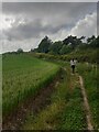
1
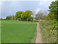
Footpath beside cereal crop
At Northstead Banks.
Image: © Russel Wills
Taken: 19 May 2015
0.03 miles
2
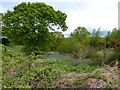
Bluebells in wood
At Northstead Banks.
The woods fall steeply to the River Wansbeck.
Image: © Russel Wills
Taken: 19 May 2015
0.06 miles
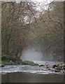
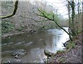
4
Riverside path to Bothal
The path here is close to the Wansbeck, in contrast to the route further back where the river runs between steep banks.
Image: © Jim Barton
Taken: 28 Sep 2017
0.08 miles
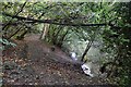
5
Field edge footpath
On a well used footpath beside a burgeoning crop.
Image: © Jeremy Bolwell
Taken: 3 Jun 2022
0.08 miles
7
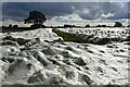
Crop under netting near Shadfen Park
Not a freak September snowfall, but crops covered by fine white plastic with the texture of netting.
Image: © Jim Barton
Taken: 28 Sep 2017
0.12 miles
8
Field path at Northstead Banks
This path to Morpeth follows field edges alongside the woodland on the south bank of the River Wansbeck.
Image: © Jim Barton
Taken: 28 Sep 2017
0.16 miles
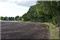
9
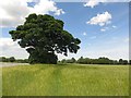
Farmland north of Shadfen Farm Mews
Farmland to the north of Shadfen Farm Mews. The expanse of crop bearing ground is punctuated by a single, large, mature tree.
Image: © Graham Robson
Taken: 3 Jun 2017
0.19 miles
10
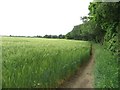
Public footpath at Northstead Banks
A public footpath along a field edge at Northstead Banks. A crop of winter barley is growing on the land.
Image: © Graham Robson
Taken: 3 Jun 2017
0.20 miles