IMAGES TAKEN NEAR TO
Hepscott, MORPETH, NE61 6LG
Introduction
This page details the photographs taken nearby to NE61 6LG by members of the Geograph project.
The Geograph project started in 2005 with the aim of publishing, organising and preserving representative images for every square kilometre of Great Britain, Ireland and the Isle of Man.

There are currently over 7.5m images from over14,400 individuals and you can help contribute to the project by visiting https://www.geograph.org.uk
Image Map
Images are licensed for reuse under creativecommons.org/licenses/by-sa/2.0
Notes
- Clicking on the map will re-center to the selected point.
- The higher the marker number, the further away the image location is from the centre of the postcode.
Image Listing (5 Images Found)
Images are licensed for reuse under creativecommons.org/licenses/by-sa/2.0
Image
Details
Distance
2
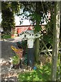
Old Milepost, A192, Barmoor Bank, North of Hepscott Bridge
The milestone is now in a front garden in Barnmoor Bank, originally being located near Coalburn Farm, south of Hepscott Bridge, on the east side of the road (NZ 2188 8381). Parish of Hepscott (Castle Morpeth District). Cast iron post, Patterson iron post, erected by the Shields & Morpeth & Branches turnpike trust in the 19th century.
Inscription reads:-
MORPETH / 2 / MILES : : No SHIELDS / 14½ / MILES
Maker:-
SMITH PATTERSON / & CO / BLAYDON
Milestone Society National ID: NB_MPNS02
Image: © Mike Rayner
Taken: 3 Jun 2016
0.19 miles

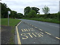
4
A192 passing Hepscott
Looking in the Morpeth direction.
Image: © Richard Webb
Taken: 26 Mar 2022
0.23 miles