IMAGES TAKEN NEAR TO
Stannington, MORPETH, NE61 6EU
Introduction
This page details the photographs taken nearby to NE61 6EU by members of the Geograph project.
The Geograph project started in 2005 with the aim of publishing, organising and preserving representative images for every square kilometre of Great Britain, Ireland and the Isle of Man.

There are currently over 7.5m images from over14,400 individuals and you can help contribute to the project by visiting https://www.geograph.org.uk
Image Map
Images are licensed for reuse under creativecommons.org/licenses/by-sa/2.0
Notes
- Clicking on the map will re-center to the selected point.
- The higher the marker number, the further away the image location is from the centre of the postcode.
Image Listing (4 Images Found)
Images are licensed for reuse under creativecommons.org/licenses/by-sa/2.0
Image
Details
Distance
1
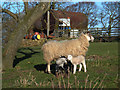
Sheep with lambs
These animals belong to North Shotton Farm. View looking north from the dead-end lane.
Image: © michael ely
Taken: 7 Mar 2007
0.01 miles
2
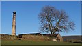
Farm chimney
At Shotton Farm. Photographer positioned just outside this square in Image
From 'British Listed Buildings'
STANNINGTON SHOTTON
NZ 27 NW
8/127 Chimney 60 metres
east of North
Shotton Farmhouse
GV II
Engine house chimney dated 1860 with initials MWR (Matthew White Ridley). Base
rough-faced stone with rock-faced quoins; stack white engineering brick with
ashlar dressings. Square base has chamfered plinth, small brick-arched openings
on east and west and dated panel on east. Circular stack, stepped and chamfered
at foot, with moulded cornice.
The attached engine house and threshing barn have been demolished, but the
chimney remains as an important hill-top landmark.
Image: © David Clark
Taken: 2 Feb 2010
0.06 miles
4
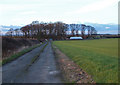
Footpath south of Shotton
Looking north from the slopes of Down Hill.
Image: © michael ely
Taken: 7 Mar 2007
0.24 miles