IMAGES TAKEN NEAR TO
The Drive, MORPETH, NE61 6AN
Introduction
This page details the photographs taken nearby to The Drive, NE61 6AN by members of the Geograph project.
The Geograph project started in 2005 with the aim of publishing, organising and preserving representative images for every square kilometre of Great Britain, Ireland and the Isle of Man.

There are currently over 7.5m images from over14,400 individuals and you can help contribute to the project by visiting https://www.geograph.org.uk
Image Map (Loading...)


Getting Data...Please wait
Leaflet Map data © OpenStreetMap
Images are licensed for reuse under creativecommons.org/licenses/by-sa/2.0
Notes
- Clicking on the map will re-center to the selected point.
- The higher the marker number, the further away the image location is from the centre of the postcode.
Image Listing (7 Images Found)
Images are licensed for reuse under creativecommons.org/licenses/by-sa/2.0
Image
Details
Distance
1
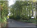
Lane to North Whitehouse Farm
Looking along the lane to North Whitehouse Farm. A sign attached to the tree on the right of warns passers by not the enter a range of derelict buildings beyond the trees. The buildings are long demolished.
Image: © Graham Robson
Taken: 12 Nov 2016
0.02 miles
2
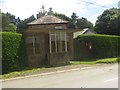
Bus shelter, Well Hill farm
A bus shelter at Well Hill Farm on the minor road between Stannington and Tranwell. The shelter is located near to the end of the road which leads to Whitehouse Farm Centre and also the site of a former children's sanatorium, latterly a hospital, which is perhaps when this shelter dates from.
Image: © Graham Robson
Taken: 3 Jul 2016
0.02 miles
3

Bus shelter and postbox, Well Hill
On Bet's Lane.
Image: © JThomas
Taken: 9 Apr 2015
0.03 miles
4
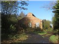
Derelict building, North Whitehouse Farm
This building lies close to the side of the drive to North Whitehouse Farm.
Image: © Graham Robson
Taken: 12 Nov 2016
0.09 miles
5
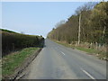
Uphill towards Tranwell
Heading north beside woodland.
Image: © JThomas
Taken: 9 Apr 2015
0.12 miles
6
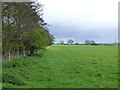
Woodland and pasture
Across the road behind the photographer is an open pit coal mine.
Image: © Russel Wills
Taken: 6 May 2015
0.15 miles
7
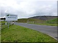
Well Hill Surface Mine
Hargreaves has opened this surface mine at Well Hill, near Morpeth, which created around 20 jobs as it extracts around 130,000 tonnes of coal over a two-year period.
Image: © Russel Wills
Taken: 6 May 2015
0.25 miles