IMAGES TAKEN NEAR TO
The Gables, MORPETH, NE61 5QY
Introduction
This page details the photographs taken nearby to The Gables, NE61 5QY by members of the Geograph project.
The Geograph project started in 2005 with the aim of publishing, organising and preserving representative images for every square kilometre of Great Britain, Ireland and the Isle of Man.

There are currently over 7.5m images from over14,400 individuals and you can help contribute to the project by visiting https://www.geograph.org.uk
Image Map
Images are licensed for reuse under creativecommons.org/licenses/by-sa/2.0
Notes
- Clicking on the map will re-center to the selected point.
- The higher the marker number, the further away the image location is from the centre of the postcode.
Image Listing (28 Images Found)
Images are licensed for reuse under creativecommons.org/licenses/by-sa/2.0
Image
Details
Distance
1
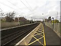
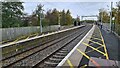
On the southbound platform, Widdrington Station
Looking north along the southbound platform of the station from which the surrounding village takes its name. The station is only served by a couple of services each day, those being local trains operated by Northern, none of the mainline intercity services stop here.
Image: © Graham Robson
Taken: 6 Mar 2017
0.08 miles
2
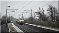
Edinburgh bound service passing Widdrington
Image: © Peter Moore
Taken: 6 Mar 2018
0.09 miles
3
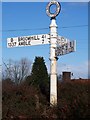
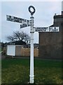
Finger post
An 'old type' of sign post that I must have driven past thousands of times and never noticed it. It has been positioned on specially prepared roadside setting just off the exact junction that it refers to.
Image: © David Clark
Taken: 22 Mar 2010
0.09 miles
4
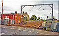
Widdrington railway station, Northumberland
Opened in 1847 by the Newcastle & Berwick Railway. View south from the level crossing towards Longhirst and Newcastle upon Tyne.
Image: © Nigel Thompson
Taken: 18 May 2010
0.09 miles
5
Widdrington station, ECML 2002
View southwards, towards Newcastle and the South on ex-NER (Newcastle & Berwick) section of the ECML, electrified 1990-91.
Image: © Ben Brooksbank
Taken: 24 Jun 2002
0.09 miles
6
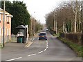
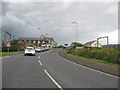
Mile Road, Widdrington Station
A mile long straight road in Widdrington Station.
Image: © Graham Robson
Taken: 6 Mar 2017
0.11 miles
8
Direction Sign ? Signpost
Located on a small green surrounded by stone blocks on the southwest side of the junction of the B1337 Grangemoor Road, Mile Road and The Signals in Widdrington Station and Stobswood parish. 3 arms and annulus finial. See also https://www.geograph.org.uk/photo/1765867.
Milestone Society National ID: NB_NZ2494
Image: © A Lloyd
Taken: 4 Jan 2019
0.11 miles
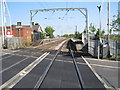
9
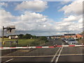
Level crossing at Widdrington Station in Northumberland
Crossing the east coast main line.
Image: © James Denham
Taken: 3 Aug 2012
0.12 miles
10
Level crossing, Widdrington Station
On the East Coast Main Line.
Image: © Barbara Carr
Taken: 22 Jun 2013
0.12 miles