IMAGES TAKEN NEAR TO
Mile Road, MORPETH, NE61 5QW
Introduction
This page details the photographs taken nearby to Mile Road, NE61 5QW by members of the Geograph project.
The Geograph project started in 2005 with the aim of publishing, organising and preserving representative images for every square kilometre of Great Britain, Ireland and the Isle of Man.

There are currently over 7.5m images from over14,400 individuals and you can help contribute to the project by visiting https://www.geograph.org.uk
Image Map (Loading...)


Getting Data...Please wait
Leaflet Map data © OpenStreetMap
Images are licensed for reuse under creativecommons.org/licenses/by-sa/2.0
Notes
- Clicking on the map will re-center to the selected point.
- The higher the marker number, the further away the image location is from the centre of the postcode.
Image Listing (7 Images Found)
Images are licensed for reuse under creativecommons.org/licenses/by-sa/2.0
Image
Details
Distance
1
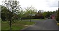
Chibburn Court
Newish residential street, Widdrington Station.
Image: © Richard Webb
Taken: 16 May 2012
0.14 miles
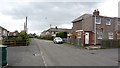
2
Chibburn Court in Widdrington Station
Image: © Peter Robinson
Taken: 27 Mar 2012
0.15 miles
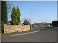
3
Old Ferneybeds Road
Residential street with a shop, Widdrington Station.
Image: © Richard Webb
Taken: 16 May 2012
0.16 miles
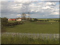
4
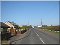
Entering Widdrington Station on Mile Road
Image: © Peter Robinson
Taken: 27 Mar 2012
0.17 miles
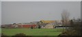
6
Ferneybeds Farm
On the southeastern edge of the village of Widdrington Station.
Image: © Barbara Carr
Taken: 22 Jun 2013
0.24 miles
7
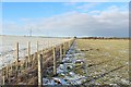
Newly planted hedge
A new hedge has been planted along the boundary between two grass fields south of Houndalee Farm. A new fence has been erected on the other side to protect the infant plants. A public footpath follows the boundary.
Image: © Graham Robson
Taken: 2 Feb 2019
0.25 miles