IMAGES TAKEN NEAR TO
The Knoll, MORPETH, NE61 5LQ
Introduction
This page details the photographs taken nearby to The Knoll, NE61 5LQ by members of the Geograph project.
The Geograph project started in 2005 with the aim of publishing, organising and preserving representative images for every square kilometre of Great Britain, Ireland and the Isle of Man.

There are currently over 7.5m images from over14,400 individuals and you can help contribute to the project by visiting https://www.geograph.org.uk
Image Map
Images are licensed for reuse under creativecommons.org/licenses/by-sa/2.0
Notes
- Clicking on the map will re-center to the selected point.
- The higher the marker number, the further away the image location is from the centre of the postcode.
Image Listing (26 Images Found)
Images are licensed for reuse under creativecommons.org/licenses/by-sa/2.0
Image
Details
Distance
1
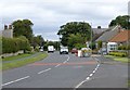
Front Street, Ellington
Ellington village was the site of the last remaining operational deep coal mine in North East England. Ellington Colliery closed on 26 January 2005. It was the last deep mine in the UK to extract coal from right under the sea.
Image: © Russel Wills
Taken: 16 Aug 2014
0.05 miles
2
Ellington, Front Street
Ellington is a small village on the coast of Northumberland. It is 20 miles north of Newcastle upon Tyne. The name of the village is thought to derive from the Saxon meaning “descendants of Ella”.
Ellington Colliery closed on 26 January 2005. It was the last deep mine in the UK to extract coal from under the sea. Today, Ellington is made up almost exclusively of private housing. It has one school, village shops, and one public house.
Image: © David Dixon
Taken: 22 May 2021
0.06 miles
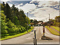
3
Front Street joins the A1068
At the roundabout.
Image: © Russel Wills
Taken: 16 Aug 2014
0.06 miles
4
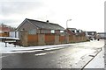
Ellington View, Ellington
A cul-de-sac of houses on the southern side of Front Street in Ellington.
Image: © Graham Robson
Taken: 2 Feb 2019
0.06 miles
5
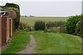
Footpath from Ellington
The start of the path to Blakemoor is at the end of Lyneburn Grange, a short residential side road.
Image: © Jim Barton
Taken: 27 Sep 2017
0.06 miles
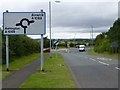
7
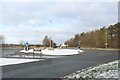
Roundabout west of Ellington
A roundabout where Front Street, Ellington, meets the A1068 on the western edge of the village. Melting snow has formed a large puddle on the roundabout.
Image: © Graham Robson
Taken: 2 Feb 2019
0.08 miles
8
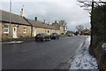
Front Street, Ellington
Looking east along Front Street. The footpath has a light covering of snow following showers overnight.
Image: © Graham Robson
Taken: 2 Feb 2019
0.09 miles
10
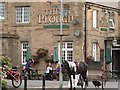
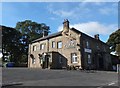
The Plough Inn
Traditional country pub in the village of Ellington in Northumberland. Apparently horse-friendly.
Image: © Iain Smith
Taken: 14 Jul 2016
0.10 miles