IMAGES TAKEN NEAR TO
Breamish, MORPETH, NE61 5LJ
Introduction
This page details the photographs taken nearby to Breamish, NE61 5LJ by members of the Geograph project.
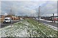
The Geograph project started in 2005 with the aim of publishing, organising and preserving representative images for every square kilometre of Great Britain, Ireland and the Isle of Man.

There are currently over 7.5m images from over14,400 individuals and you can help contribute to the project by visiting https://www.geograph.org.uk
Image Map
Images are licensed for reuse under creativecommons.org/licenses/by-sa/2.0
Notes
- Clicking on the map will re-center to the selected point.
- The higher the marker number, the further away the image location is from the centre of the postcode.
Image Listing (30 Images Found)
Images are licensed for reuse under creativecommons.org/licenses/by-sa/2.0
Image
Details
Distance
1
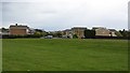
Playing field, Ellington
A park in a 1960s or 1970s housing development.
Image: © Richard Webb
Taken: 16 May 2012
0.07 miles
2
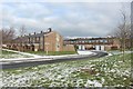
Springwell Drive, Ellington
Rows of terraced houses in Ellington. The row nearest the camera is Springwell Drive, the next row on the far side of the road is Dene View.
Image: © Graham Robson
Taken: 2 Feb 2019
0.13 miles
3
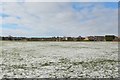
Playing field, Ellington
A playing field between housing estates on the edge of Ellington. The ground has a light covering of snow following overnight snow showers.
Image: © Graham Robson
Taken: 2 Feb 2019
0.14 miles
4
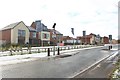
Traffic calming, Lynmouth Road, Ellington
Islands forcing vehicles to slow down on Lynemouth Road. Behind are new houses built as part of a larger development by Ascent Homes, a council owned house builder.
Image: © Graham Robson
Taken: 2 Feb 2019
0.15 miles
5
Grass area, Lynemouth Road, Ellington
An area of grass separating Lynemouth Road (on the right) and an access road to residential properties (on the left). A wide, winding line of daffodils are emerging from the grass in the centre of the area between the two roads.
Image: © Graham Robson
Taken: 2 Feb 2019
0.15 miles
6
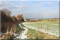
Public footpath, Ellington
A footpath along the edge of an arable field on the edge of Ellington.
Image: © Graham Robson
Taken: 2 Feb 2019
0.15 miles
7
Main entrance to housing development, Lynemouth Road, Ellington
The main entrance into the development of new houses by Ascent Homes on the southern side of Lynemouth Road in Ellington.
Image: © Graham Robson
Taken: 2 Feb 2019
0.16 miles
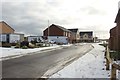
9
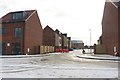
New Road, Ascent Homes development, Ellington
A new road built as part of the Wayside Point housing development by Ascent Homes on the southern side of Lynemouth Road in Ellington.
Image: © Graham Robson
Taken: 2 Feb 2019
0.18 miles
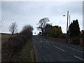
10
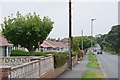
Cresswell Road, Ellington
Bungalows on the minor road from Cresswell.
Image: © Jim Barton
Taken: 27 Sep 2017
0.18 miles