IMAGES TAKEN NEAR TO
St. Bartholomews Close, MORPETH, NE61 5JX
Introduction
This page details the photographs taken nearby to St. Bartholomews Close, NE61 5JX by members of the Geograph project.
The Geograph project started in 2005 with the aim of publishing, organising and preserving representative images for every square kilometre of Great Britain, Ireland and the Isle of Man.

There are currently over 7.5m images from over14,400 individuals and you can help contribute to the project by visiting https://www.geograph.org.uk
Image Map (Loading...)


Getting Data...Please wait
Leaflet Map data © OpenStreetMap
Images are licensed for reuse under creativecommons.org/licenses/by-sa/2.0
Notes
- Clicking on the map will re-center to the selected point.
- The higher the marker number, the further away the image location is from the centre of the postcode.
Image Listing (61 Images Found)
Images are licensed for reuse under creativecommons.org/licenses/by-sa/2.0
Image
Details
Distance
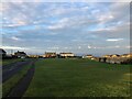
2
The road to Druridge
Looking north from Cresswell. The cleared tracks meant that the road was passable with no more than reasonable care.
Image: © Alan Murray-Rust
Taken: 24 Dec 2009
0.09 miles
3
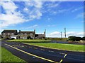
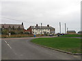
Cresswell Village centre
Cresswell is a pretty little place at the southern end of Druridge Bay. The road on the right leads north along the bay.
Image: © Robert Graham
Taken: 12 Sep 2012
0.09 miles
4
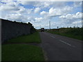
Coastal road towards Druridge Bay
National Cycle Route 1.
Image: © JThomas
Taken: 21 Jul 2012
0.09 miles
6
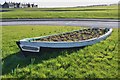
Garden in a rowing boat, Cresswell
An old boat named the 'Tommy Cowan' now used as a planter on a grassy triangle in the village centre.
Image: © Jim Barton
Taken: 23 Feb 2016
0.10 miles
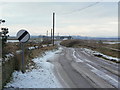
7
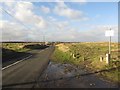
Minor road north of Cresswell
The minor road which follows the coast a short distance to the north of Cresswell. The coast is over the dunes on the right.
Image: © Graham Robson
Taken: 24 Jan 2018
0.10 miles
8
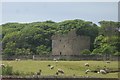
Cresswell Tower
A towerhouse, 14th century with 18th century additions. Listed grade II*
Image: © Michael Dibb
Taken: 25 May 2011
0.11 miles
9
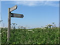
England Coast Path Signage, Cresswell
The England Coast Path, which when completed will be the longest waymarked and managed coastal path in the world, passes through the North East of England from the Wash in the south to the Scottish Border in the north. This section, which heading north, is about to enter Blakemoor Links, is also part of the Northumberland Coast Path (indicated by the blue 'N' logo).
Image: © Geoff Holland
Taken: 12 Jun 2023
0.11 miles
