IMAGES TAKEN NEAR TO
Ellington, MORPETH, NE61 5JR
Introduction
This page details the photographs taken nearby to NE61 5JR by members of the Geograph project.
The Geograph project started in 2005 with the aim of publishing, organising and preserving representative images for every square kilometre of Great Britain, Ireland and the Isle of Man.

There are currently over 7.5m images from over14,400 individuals and you can help contribute to the project by visiting https://www.geograph.org.uk
Image Map (Loading...)


Getting Data...Please wait
Leaflet Map data © OpenStreetMap
Images are licensed for reuse under creativecommons.org/licenses/by-sa/2.0
Notes
- Clicking on the map will re-center to the selected point.
- The higher the marker number, the further away the image location is from the centre of the postcode.
Image Listing (7 Images Found)
Images are licensed for reuse under creativecommons.org/licenses/by-sa/2.0
Image
Details
Distance
1
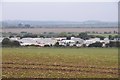
Caravan site near Ellington
A site in farmland north of Ellington.
Image: © Jim Barton
Taken: 27 Sep 2017
0.09 miles
2
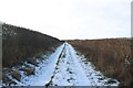
Track east of Highthorn
A track to the east of Highthorn which is followed by a public bridleway.
Image: © Graham Robson
Taken: 2 Feb 2019
0.12 miles
3
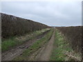
Bridleway heading east
From Cresswell towards the A1068.
Goes through some pretty boggy ground - would not like to tackle this one in winter.
Image: © JThomas
Taken: 11 Apr 2013
0.12 miles
4
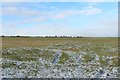
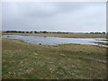
Grass field east of Highthorn
A flat field of grass to the east of Highthorn farm.
Image: © Graham Robson
Taken: 2 Feb 2019
0.13 miles
6
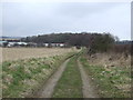
Bridleway heading east towards the A1068
Caravan park visible on the left.
Image: © JThomas
Taken: 11 Apr 2013
0.21 miles
7
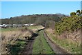
Track to Highthorn
The track joins the A1068 E of Widdrington Station. Note the gorse just coming into bloom.
Image: © Jim Barton
Taken: 23 Feb 2016
0.22 miles