IMAGES TAKEN NEAR TO
Druridge Bay, MORPETH, NE61 5EG
Introduction
This page details the photographs taken nearby to NE61 5EG by members of the Geograph project.
The Geograph project started in 2005 with the aim of publishing, organising and preserving representative images for every square kilometre of Great Britain, Ireland and the Isle of Man.

There are currently over 7.5m images from over14,400 individuals and you can help contribute to the project by visiting https://www.geograph.org.uk
Image Map
Images are licensed for reuse under creativecommons.org/licenses/by-sa/2.0
Notes
- Clicking on the map will re-center to the selected point.
- The higher the marker number, the further away the image location is from the centre of the postcode.
Image Listing (33 Images Found)
Images are licensed for reuse under creativecommons.org/licenses/by-sa/2.0
Image
Details
Distance
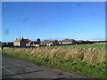
2
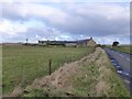
Druridge and its dunes
Access to the miles of sands on Druridge Bay.
Image: © Russel Wills
Taken: 2 Feb 2013
0.02 miles
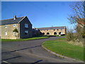
3
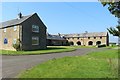
Converted farm buildings, Druridge
The farm steading at Druridge has been converted into residential accommodation.
Image: © Graham Robson
Taken: 26 Aug 2019
0.03 miles
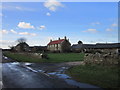
4
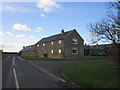
Druridge
A row of modernised cottages in the tiny hamlet of Druridge which gives its name to a famous bay on the Northumberland coast.
Image: © Oliver Dixon
Taken: 22 Jul 2011
0.03 miles
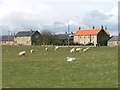
5
View of Druridge
Looking West at this little hamlet just back from the coast at Druridge Bay.
Image: © Robert Graham
Taken: 7 Nov 2011
0.04 miles
6
Druridge
The tiny hamlet of Druridge gives its name to the ten kilometre bay.
Image: © Mick Garratt
Taken: 8 Apr 2006
0.04 miles
7
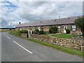
Converted farm buildings at Druridge
Former stables converted to apartments in this little hamlet next to the coast.
Image: © Robert Graham
Taken: 7 Nov 2011
0.05 miles
9
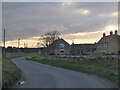
Evening light, Druridge
Cottages and houses at Druridge with one of the Sisters Wind Farm turbines in view.
Image: © Jim Barton
Taken: 17 Mar 2022
0.06 miles
10
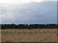
Grassland, Druridge
Flat ground inland from the dunes with some of the Widdrington Wind Farm turbines in the background.
Image: © Jim Barton
Taken: 14 Mar 2022
0.10 miles