IMAGES TAKEN NEAR TO
Primrose Way, MORPETH, NE61 5BR
Introduction
This page details the photographs taken nearby to Primrose Way, NE61 5BR by members of the Geograph project.
The Geograph project started in 2005 with the aim of publishing, organising and preserving representative images for every square kilometre of Great Britain, Ireland and the Isle of Man.

There are currently over 7.5m images from over14,400 individuals and you can help contribute to the project by visiting https://www.geograph.org.uk
Image Map
Images are licensed for reuse under creativecommons.org/licenses/by-sa/2.0
Notes
- Clicking on the map will re-center to the selected point.
- The higher the marker number, the further away the image location is from the centre of the postcode.
Image Listing (23 Images Found)
Images are licensed for reuse under creativecommons.org/licenses/by-sa/2.0
Image
Details
Distance
1

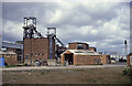
Ellington Colliery Entrance
Entrance to the colliery, which has now closed (possibly under curious circumstances...?)
Image: © Steve McShane
Taken: 30 Oct 2005
0.04 miles
2
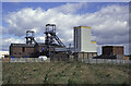
Ellington Colliery
This was the last deep pit in Northumberland and has now been demolished.
Image: © Chris Allen
Taken: 29 Jun 1994
0.06 miles
3
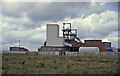
Ellington Colliery
The last deep pit in Northumberland and now demolished. I can no longer decide where the camera was but thought it better to post an image of a fast disappearing part of our industrial heritage.
Image: © Chris Allen
Taken: 29 Jun 1994
0.06 miles
4
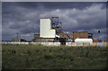
Ellington Colliery
The last deep pit in Northumberland and now demolished.
Image: © Chris Allen
Taken: 29 Jun 1994
0.06 miles
5
Ellington Colliery
Location might need adjusting and direction is unknown
Image: © Chris Allen
Taken: 29 Jun 1994
0.06 miles
6
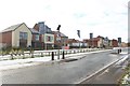
Traffic calming, Lynmouth Road, Ellington
Islands forcing vehicles to slow down on Lynemouth Road. Behind are new houses built as part of a larger development by Ascent Homes, a council owned house builder.
Image: © Graham Robson
Taken: 2 Feb 2019
0.08 miles
7
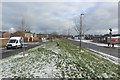
Grass area, Lynemouth Road, Ellington
An area of grass separating Lynemouth Road (on the right) and an access road to residential properties (on the left). A wide, winding line of daffodils are emerging from the grass in the centre of the area between the two roads.
Image: © Graham Robson
Taken: 2 Feb 2019
0.08 miles
8

Main entrance to housing development, Lynemouth Road, Ellington
The main entrance into the development of new houses by Ascent Homes on the southern side of Lynemouth Road in Ellington.
Image: © Graham Robson
Taken: 2 Feb 2019
0.09 miles
9

Springwell Drive, Ellington
Rows of terraced houses in Ellington. The row nearest the camera is Springwell Drive, the next row on the far side of the road is Dene View.
Image: © Graham Robson
Taken: 2 Feb 2019
0.09 miles
10

Miners monument at Ellington
This is one of the many monuments to commemorate the defunct coal mining industry which may be found in former pit villages throughout the North-East Coalfield. This one stands opposite the old Ellington Colliery Institute (now the Ellington Welfare Social Centre).
Image: © Oliver Dixon
Taken: 22 Jul 2011
0.09 miles